Wednesday, 30 December 2015

The Lewis Chessmen
- the oldest northern chess game


The Lewis Chessmen are a group of 12th-century (1150-1200) chess pieces, most of which are carved in walrus ivory, from 3.5 to 10 cm high.


Discovered in 1831 on a sand bank at Uig Bay, on the west coast of the Isle of Lewis, Outer Hebrides, Scotland, they are a rare complete medieval chess set.

Uig Bay, on the west coast of Lewis.

Most of  the set is owned and usually exhibited by the British Museum in London; 11 pieces belong to the National Museum of Scotland in Edinburgh, and other 6 will be displayed at the new Museum installed at Lewes Castle in Stornoway.

Lewes Castle, Stornoway.

Stornoway, Isle of Lewis, 58º N

The chessmen were probably made in the 12th century in Trondheim, Norway, at 63º N, not far from the Arctic Circle ! By the time, the Outer Hebrides were ruled by the Viking christian kingdom of Norway.

Some similar pieces carved in walrus ivory can be seen at the fabulous Nidaros cathedral in Trondheim, which was started at the 11th century. By the time, wealthy trader families living in the town were able to pay craftsmen for high-quality chess pieces.

The chess game had been introduced in Europe by 900-1000 AD, brought from India (Persia ?) by Arab merchants.


These Viking Chess figures recall the berserkr warriors of the Norse sagas.

The fierce Norse knight.


It's commonly believed that the Lewis Chessmen were hidden (or lost) after some accident occurred during their transport from Norway to some wealthy Norse town. They were enclosed in a stone cist on a dune, so it seems likely they were buried for safe keeping. The large number of pieces and their lack of wear may suggest that they were the stock of a trader.


The pieces are elaborately worked in the forms of seated kings (8) and queens (8), bishops, knights on their mounts, standing warders, and pawns shaped like obelisks.

The Queen.

Queen's back.

The 'bishop' was a christian version of the original indian 'elephant'. Later the Arabs changed it to "camel" (alfil), but their pieces had to be non-figurative, so the alfil was a cone with beak-shaped sideways like two bosses.

In Europe, the alfil word was transformed to foul ('fou', in France), and the camel became bishop in anglo-saxon languages because of its mitre-like shape.


More:
http://www.messagetoeagle.com/mystery-beautiful-viking-uig-chessmen-found-isle-lewis-scotland/


Monday, 21 December 2015

400 000 - this solstice deserves a feast !


This Winter Solstice, I am reaching - or have reached by now - 400 000 visits to Ultima Thule ! That is a medium-size city already, and though it took over 5 years to come to this, I am celebrating the pretty round number. So many voyages done here to remote ice-covered territories !


Some maps tell the story behind the numbers. This one, from February 2013, shows readers from the Arctic and the Far North:


From Inuvik to Khabarovsk, through Pond Inlet, Tasiilaq, Mo-I-Rana... all of them places I wrote about here. Hello there !

Have a nice Christmas, thanks for being part of my


Thursday, 17 December 2015

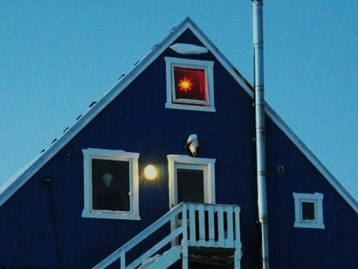
Red-orange Christmas stars decorate the Greenlandic windows

Greenland celebrates the Holidays with a particular joy: as the polar night reaches its almost 24h long duration, a feast of lights, community singing and gourmet eating is a welcome break. The trees are lightened up, and at the windows shines a star, generally of orange or reddish color, cheering up in the darkness.

The Christmas tree was enlightened at Nuuk in the presence of a small croud. It's a very special happening in the December arctic nights.

At Sisimiut, above the Arctic Circle (66ºN), the whole town was present, some 6000.


There is some degree of competition - who has the most beautifully shinning star ? - even though a unique model is the most commonly found.


Kamgan Ukudigaa                             Happy Holidays
Quyanaghhalek Kuusmemi               Merry Christmas


Saturday, 5 December 2015

Base San Martín, Barry Island - red on white


Marguerite Bay (Bahía Margarita), on the west coast of the southern tip of the Antarctic Peninsula, was chosen for its relatively mild climate and friendly shores to be the location of several antarctic polar stations. I've written about Rothera (UK) sometime ago, and in its vicinity is San Martin, an Instituto Antártico Argentino (IAA) base.


Marguerite Bay is a large and deep bay, but the access is quite difficult most of the year because the water surface is frozen, or dangerously covered with moving ice floes. Small islands, underwater cliffs and rocks compose a net of narrow navigable canals. Only during the short antarctic summer is the route easy for supply ships as well as for tourist cruises or scientific expeditions.

'Roman Four' promontory, a 830 m high cliff with the form of IV.


Barry Island was first charted by the British Graham Land Expedition (BGLE) under John Riddoch Rymill, who used it for a base in 1936 and 1937. He also named it after the eldest son of an expedition member.

On one of the small islets, Argentina built in 1951 a small station for scientific purposes, a few scattered red buildings that are easily visible from the sea.

San Martín, Barry Island.

Coordinates:  68° 07´ S , 67° 06´ W
       350 km south of the Antarctic circle.
Occupation:  ~ 20, all year round.


Base San Martín is a permanent, all year-round Antarctic base for scientific research on climate, seismology and geodesics.


The increased Antarctic activity that Argentina developed since 1940, along with the interest to exercise effective sovereignty over one of the most remote areas of Antarctica, created the need for a scientific station located south of the Antarctic Circle.

The main house, at right: dormitory, canteen and leisure rooms. At left, the laboratory.

A quick description: one two-story main house with double wooden walls, an emergency house, five metal warehouses for supplies, housing for the dog packs, a power generator and the four towers for the 25 meters high antenna.

The Radio Station and communication antennas.

The IAA meteorological station within the base has been for long providing detailed weather records and developing forecasts for the navigation of the sea waters adjacent to the Antarctic Peninsula.

San Martín looking at the red laboratory.


The station's main house.

At the time of its foundation in 1951, it was the first human settlement south of the Antarctic Circle.

The oceanographic ship ARA Puerto Deseado.

In order to transport the personnel and materials to Marguerite Bay, the navy has several polar ships, some with ice-breaking capacities.

The Almirante Irizar, bought from Russia.


All emergency - supply, rescue missions - are usually done by helicopter, and in winter relief crew comes by helicopter transfer. In adequate weather conditions, the team can also be reached by plane.

The Twin Otter is the most popular light plane for polar operations.

The regular post delivery is a basic need for the crew.

Two Glaciars - Uspallata and McClary - face Barry Island. Now, just look how magnificent is Marguerite Bay and its glaciars at sunset, or during the midnight sun by the antarctic summer solstice:


Saturday, 28 November 2015

Rackwick Bay and the Old Man of Hoy, Orkney Islands


The Orkneys can be anyone's Ultima Thule. They have the remoteness, the preserved authenticity, the wilderness of cliffs, bays and seas, quaint towns with an atmosphere and a history of their own. And they were certainly on the route of Pytheas the Greek when he adventured on the northern icy waters.


On the west coast of Hoy, one of the Orkney Islands, there are two great sceneries that attract visitors to the rather wild coast : Rackwick Bay and the Old Man of Hoy, a slim but high rock column.


Rackwick Bay

Coordinates: 58° 52' N, 03° 23' W.


The bay in half moon shape is a strikingly desolate yet beautiful beach between red sandstone cliffs.


A glorious pink sandy beach with  giant sea-smoothed boulders lies below the cliffs. Only the boom of the sea can be heard on a summer day.


The tiny settlement, previously a farm, was converted to a boothy for visitors, a hostel and a small museum.

The boothy at Rackwick.


Rackwick has its own microclimate and is often warmer than elsewhere in Orkney. The terrain is hard to walk on but the views and landscape make the suffering worthwhile!


Rackwick is also the home to the Crows Nest Museum and  the Rackwick Hostel.

Craa Nest Museum occupies three old farming cottages.

These are the oldest houses on the bay, from a hundred years ago.


The Rackwick Hostel

The best option if you must spend the night at the bay.

The three-mile path to the Old Man of Hoy.

Old Man of Hoy

Coordinates: 58° 15′ N,  5° 23′ W


The rock is tallest sea stack in Europe (137m) and the most famous sight on the island if not all Orkney.

The column is probably the remaining end of a complete arch.


-------------

A handful of houses are scattered around Rackwick Bay, but there’s no shop, pub or café which is probably the reason that the place has retained its charm. But also reminds us of how har life used to be there:

No bloody sport, no bloody games,
No bloody fun; the bloody dames
Won't even give their bloody names

                                                                                     atribb. to Captain Hamish Blair


Has inspired this little jewel on the piano, Rackwick Bay by Phamie Gow: