Wednesday, 7 March 2012

Uummannaq, Greenland - an arctic gem facing Canada


A charming inuit settlement in the east cost of Greenland, north of Disko Bay and in front of Canada's Baffin Island, Uummannaq is situated in a magnificent arctic scenery.

The harbour seen as the ferry boat is leaving at low light.

Uummannaq is one the island's northernmost municipalities, surrounded by a majestic and harsh environment of tall mountains, fjords, many glaciers and icebergs, with a rich arctic fauna, particularly fish and sea mammals.


Around 1500 people live in Uummannaq.

Location: 70°40′ N, 52°07′W - 590 km north of the Arctic Circle.

Founded in 1763, the town is a hunting and fishing base, particularly of halibut. The fish are processed in a modern canning factory.


Uummannaq is located on a 12 km2 island at the foot of a large heart-shaped mountain that gave its name:

Uummannaq means, in greenlandic inuit, "The Heart Shaped".

Uummannaq Mountain, rising very sharply to the height of 1170m.
is the most prominent mountain in the Arctic part of the west coast of Greenland.

The mountain is a landmark of Greenland, often reproduced in art.

Dog sledding is one of the main tourist avctivities.

Uummannaq's hotel has a fantastic view over the fjord.

View from the hotel's esplanade

The town center, and the many-coloured houses that add charm to the scenery.


Uummannaq's church


The church isn't very old (1935), but it is an unusual design for Greenland - it was built from local granite.

Close to the church, an old turf house, where the first settlers - mainly whale hunters - lived. It's part of the town's museum, that exhibits also fishing and hunting tools, traditional clothing, old kayaks and oumiaks, photos and charts.

Whaling harpoons at the museum.

Uummannaq Polar Institute

Founded in 2007, it´s an institution that works to conserve Greenland’s local culture and to promote educational programs for young people.

Uummannaq is also home to Uummannaq Music - the world's northernmost music platform on sea ice:

Arctic dancing during the festival.

http://uummannaqmusic.com/


********************************************
A presentation of Uummannaq and its music festival:

Wednesday, 22 February 2012

Pond Inlet, arctic village with a difference


Pond Inlet (pop. 1400) is situated at 72º 41’N, 78º 00’W, about 700 km north of the Polar Circle, on the northeastern shore of Baffin Island, across from Bylot Island.


The Inuit call Pond Inlet Mittimatalik or the resting place of Mittima, an Inuk whose memory has been perpetuated through the years. Back in 1930's, Inuit were coming to Mittimatalik mostly in the spring to trade furs and to spend few weeks at the trading post or at the mission.


The comunity is considered one of Canada's "jewels of the North": a gorgeous scenery, mountain ranges all around, icebergs most often, several dozen glaciers, explorable ice caves, and many grand and picturesque inlets overlooking the waters of Eclipse Sound across to the towering mountains and glaciers of Bylot Island and Sirmilik National park.

Inuit mother and child

Local Ulaajuk school

Caribou, fox, seal or fish are the main resources of the settlement's population.


Inuksuk Residence,
Richard Carbonnier's innovative arctic house


Richard Carbonnier is a Montreal-born architect who spent four years building this tube house to suit – and tread lightly on – the polar environment.

The building stands on three floating footings. The curves allow the building to stand up to high winds better than a conventional design.

Made from three large aluminum cylinders that intersect at a living room space

The amazing Bylot Island

This small island, at 73°16′N, 78°30′W , north of Baffin Island right across a sea straight from Pond Inlet, has been for long an attraction for painters and explorers. Glaciers and mountains with an uncommon profile decorate this uninhabitated natural park, where polar bears come often to have their cubs.

Hoodoos in Bylot


Mount Thule, on Bylot island, by Lawren Harris

An icon for this blog!


Friday, 17 February 2012

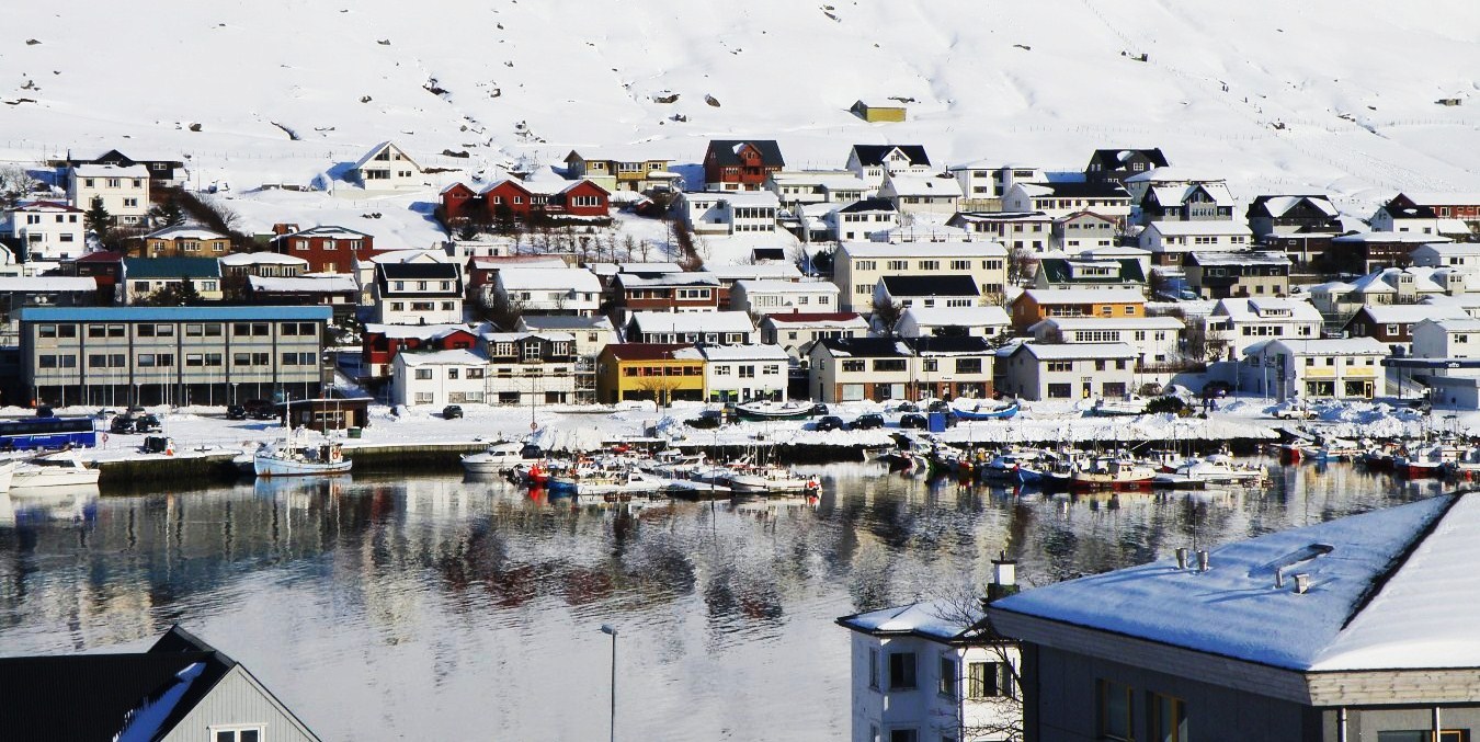
Klaksvik, a lively faroese harbour with a view

Klaksvík (pop. 5000) is the second largest town of the Faröe Islands.

Coordinates: 62°13′N, 6°34′W


Klaksvik
is located on both rivers of a small fjord in Borðoy island, one of the archipelago's northernmost islands .

Klaksvik lies between two inlets lying back to back.

As it is situated around a very well-protected bay, local skippers and their crews moved in here and the town started to develop and became the main fishing port in the islands.


Háfjal mountain (647 m) is unmissable wherever you are in Klaksvik. It's at the top end of the inlet body of water, where an important harbour with fishing industry and a modern fishing fleet makes Klaksvik the second largest town in the Faröe.


The first settlement at Klaksvík dates back to Viking times, but it was not before the 20th century that the district merged to form a large, modern Faroese town that became the cultural and commercial centre for the Northern Isles and the Faröe Islands as a whole.

Háfjal in winter

The main landmarks are the church, Christians - kirkjan, the museum, Nordoya Fornminnissavn, the brewery Føroya Bjór, the Weaving school and the Roykstovan pub.

Interior of modern Christians - kirkjan (1963), dedicated to the memory of the sailors who lost their life during Second World War.

Nordoya Fornminnissavn Museum, Klaksvik, Vagar, Faroe Islands
Nordoya Fornminnissavn Museum

Roykstovan pub
A smoky pub to meet friendly locals and have a few drinks.

Føroya Bjórbrewery, a Faroese family brewery, founded in 1888.

Old and new side by side in Klaksvik

The beautiful Klaksvík Park

Klaksvík in late afternoon light.

****************************************


The island of Borðoy

Borðoy is an island of almost 100 km2, with an irregularly cropped coast and fabulous sceneries - waterfalls, sea inlets, small harbours and hamlets looking at the sea from up the cliffs.


Múli, a very small hamlet that is one of the oldest in the islands, lies on the outermost northern edge of Borðoy's east coast, in a remote and almost inaccessible location (see map). Its settlement can be dated back to the 13th century.

Borðoy in summer

Borðoy in winter