Sunday, 20 September 2015
Arvo Pärt, Passacaglia
Arvo Pärt is undoubtfully the greatest composer of our times. He was born is Estonia, in 1935, and works mainly on sacred classical music, in a minimalist style.
Somehow I find him adequated to our purposes here at Ultima Thule: the music of Pärt talks of remoteness and distance, isolation and meditation, but also of discovery and new horizons.
This short Passacaglia is one of his most brilliant musical works; dissonations in a crescendo rythm, like in a breathless ride, away from or to reach something, leave a final feeling of fulfillment.


Monday, 7 September 2015
Inuit Arts,a short presentation
I´m not, of course, an art expert, nor am I someone who deeply studied the Inuit native peoples of Alaska, Arctic Canada or Greenland.
I just collected some of the arts and craft examples I love the most - and my eyes are those of an European, biased by western culture. That said, enjoy and I hope it can motivate to research for more.
Note that some of the works are from unknown authors.
Inuit Arts, from Mario Ricca
Saturday, 8 August 2015
Nightmute, Alaska - isolation and poverty on the wet tundra.

Nightmute (Negtemiut in Yup'ik) is a village north of the Kuskokwim Delta, on Nelson Island, and on the banks of the Ninglick river - a canal in fact, between the island and mainland. This is tundra territory, patched by several winding arms of water and lakes.

Coordinates: 60° 29' N, 164° 49' W
Population: ~ 280

The nearest settlement is Chefornak, to the south, and it's already been on a post at U.T. here.

There are no practicable roads. Nightmute can be reached by snowmobile or Bush flying, and in summer by boat along the rivers and canals.


The main buildings in town - the School, the Community Center.

Housing for teachers.

The village has no streets - the wet terrain doesn't allow. The houses are connected by wooden boardwalks.


Most residents are Yup'ik natives, living a traditional subsistence lifestyle of hunting, fishing, and gathering. Fishing for salmon and whitefish provides a staple of the Yup'ik diet along the river.

There is a community center, health clinic and most important of all there is a school, the center of local life.


As other native american communities, Yup'ik eskimos are skilled at making refined grass baskets:


The Community Service Center, where most cultural life and leisure takes place.

The Yukon–Kuskokwim Delta National Wildlife Refuge

The Wildlife Refuge is located where the Yukon and Kuskokwim rivers empty into the Bering Sea on the west coast of Alaska.


This is one of the largest deltas in the world, larger than the Mississippi Delta. Consisting mostly of tundra, the area is protected as part of the Yukon Delta National Wildlife Refuge.


The river's name comes from the Yup'ik kusquqviim, recorded by a Russian sailor in 1826. The principal economic activities along the river have historically been fur trapping and fishing.
Besides the tundra vegetation, the Refuge is home to foxes, bears, salmon-family fish and many bird species:


------------------------
Nightmute is, alas, a poorly developed settlement. It's sad to say but it's true: the U.S. doesn't care and protect its native peoples as Canada does; the Nunavut and Northwest Territories native settlements benefit largely more from civilization´s comfort than their Alaskan counterparts.

Saturday, 25 July 2015
Skarvanes and Sandúr in Sandoy
All these are in the Faroe Islands, and there are more: Skálavik, Skopun...

Skarvanes is a settlement in the west coast of Sandoy, one if the Faroe islands. Other settlements on the island are Húsavík, Sandoy, Dalur, Sandúr (the main town) and Skopun (the main harbour).

Skarvanes is a tiny hamlet - there are only three families living there.
 Most of the houses in the scenic village are used as summer house.

The old watermill with grass roofs is still well preserved.

Coordinates: 61°47′ N, 6°44′ W
Population : ~ 13
 The seaside road views to the nearby smaller islands. Watch for sheep !
The faroese painter Díðrikur á Skarvanesi (1802-1865) was born in Skarvanes. Another Faroese artist, Ruth Smith, has a few paintings of Skarvanes:
 Sakarvanes, by Ruth Smith
Sandúr is the largest village on the island Sandoy. Sandúr means ‘Sand’ and Sandoy means ‘sandy island’.

The settlement is located between an inlet and the largest lake on the island , the Sandsvatn, rich in trout and salmon.

Sandúr was a site of the Viking parliament, the Thing, where every year the spring assembly Várting was held.
Coordinates: 61°50′ N, 6°48′ W
Population: ~560
There are two main attractions in Sandúr: the museum and the church.

Sands Listasavn Art Museum
The museum and the art works displayed inside were a gift from Sofus Olsen. It was built in 2005.


The church, also under a grass-covered roof, was built in 1839 over several other previous older churches - the oldest found to be from the 11th century!

Excavations have shown that around year 1000 a norse stave church was standing where the present church is now.
 Entrance door
The island of Sandoy is rather flat, with good farming land, and not so spectacular as some other in the Faroese archipelago.
 Scenic roads are narrow and dangerously winding above the ocean.
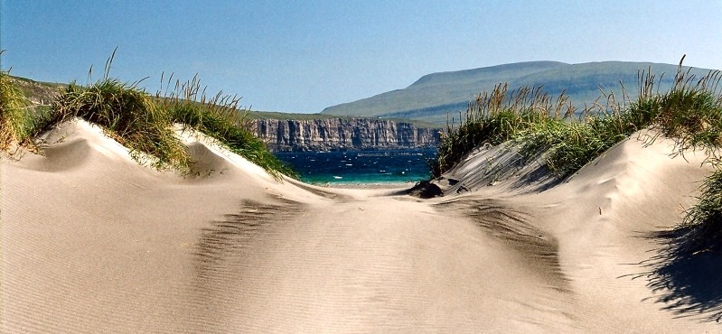
But its coast allows fabulous views to neighbour Stóra Dimun and Lítla Dimun, rough cliffs near Sandúr, and there are more sand and beach areas on Sandoy than on the other islands.
 The dunes near Sandúr


Skarvanes is a settlement in the west coast of Sandoy, one if the Faroe islands. Other settlements on the island are Húsavík, Sandoy, Dalur, Sandúr (the main town) and Skopun (the main harbour).

Skarvanes is a tiny hamlet - there are only three families living there.


The old watermill with grass roofs is still well preserved.

Coordinates: 61°47′ N, 6°44′ W
Population : ~ 13

The faroese painter Díðrikur á Skarvanesi (1802-1865) was born in Skarvanes. Another Faroese artist, Ruth Smith, has a few paintings of Skarvanes:

Sandúr is the largest village on the island Sandoy. Sandúr means ‘Sand’ and Sandoy means ‘sandy island’.

The settlement is located between an inlet and the largest lake on the island , the Sandsvatn, rich in trout and salmon.

Sandúr was a site of the Viking parliament, the Thing, where every year the spring assembly Várting was held.
Coordinates: 61°50′ N, 6°48′ W
Population: ~560
There are two main attractions in Sandúr: the museum and the church.

Sands Listasavn Art Museum
The museum and the art works displayed inside were a gift from Sofus Olsen. It was built in 2005.


The church, also under a grass-covered roof, was built in 1839 over several other previous older churches - the oldest found to be from the 11th century!

Excavations have shown that around year 1000 a norse stave church was standing where the present church is now.

The island of Sandoy is rather flat, with good farming land, and not so spectacular as some other in the Faroese archipelago.

But its coast allows fabulous views to neighbour Stóra Dimun and Lítla Dimun, rough cliffs near Sandúr, and there are more sand and beach areas on Sandoy than on the other islands.

Thursday, 23 July 2015
Good! Thick sea ice persisted northwest of Greenland !
As I showed in a previous post, this was not a bad year for Arctic ice. In fact, the volume of Arctic sea ice increased by a third following the unusually cool summer of 2013.

Lead author Rachel Tilling, from the Centre for Polar Observation and Modelling (CPOM) at UCL, said,
“The summer of 2013 was much cooler than recent years, with temperatures typical of those seen in the late 1990s. This allowed thick sea ice to persist northwest of Greenland because there were fewer days when it could melt. Although models have suggested that the volume of Arctic sea ice is in long-term decline, we know now that it can recover by a significant amount if the melting season is cut short.”
http://www.esa.int/Our_Activities/Observing_the_Earth/CryoSat/Cool_summer_boosts_Arctic_ice
Subscribe to:
Posts (Atom)