At over 59º N, this is almost sub-arctic Scotland, in a small island northeast of Orkney Mainland. Whitehall is two hours away by ferry from Kirkwall, the most populated and nearest town with urban and social services.

Whitehall is a small village with about 50 houses. It has a fishing harbour and ferry pier, post office, hotel, pub and B&B, shop, café and heritage centre, a chapel. And a small bank branch rarely open.

In the Orkneys, Stronsay is known as the 'star island' for its shape. Bays, coves and cliffs carve the low coastline (max. 44 m). A larger map is displayed at the end of this post.

Whitehall, Stronsay Island, Orkneys
Coordinates: 59° 8′ N, 2° 36′ W
(as Uppsala, Norway)
Population: ~ 370

The village spreads along its main and only street, between the arms of its two piers. Most of its properties are hints of considerable past wealth.

Aligned in a curved bay waterfront, houses look like fancy dwellings dating from the days when the vast herring fleet came in, from the 17th century until the 1930s.


Whitehall takes its name from a (white) house built in the 1670s that has been demolished.

Until the 2nd World War, Whitehall had been the biggest herring port in the northern Orkney Islands, trading mainly with the Baltic ports of Russia and Eastern Europe. This wealth brought a larger population and was evident in some of the houses.

These fine gabled houses witness the wealth earned from the fisheries.


Some of Whitehall houses:


A few houses have glassed sunrooms like this to enjoy the sea view in sunny days.


One only shop:


Not many customers, so, one only opening day!

As for reading the news:

A village between two piers.

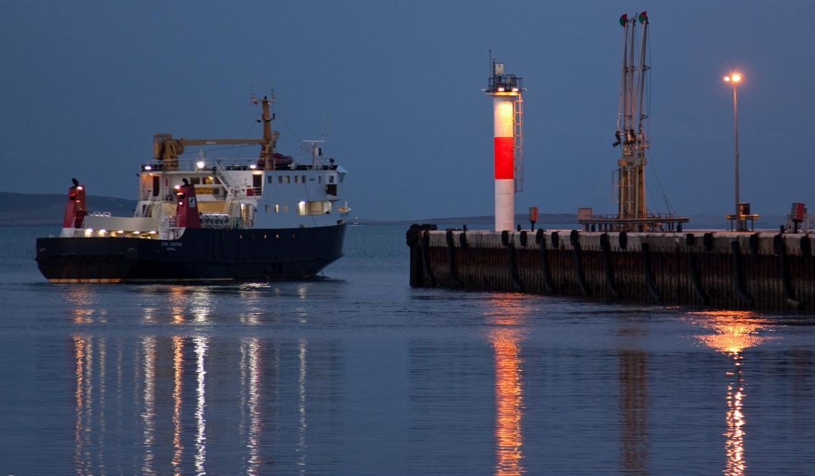
Whitehall harbour is the terminus for the ferry service from Kirkwall.


The first building as you leave the pier is the Fish Mart, a long house which once was the local market and now is a hostel and café.

Offering teas, coffees, homemade cakes, light lunches and accommodation.

The two piers enclose a herring fishing history.

Whitehall historical growth and decline is closely linked to the herring industry, which was initially developed by the Dutch.

At its height, 300 boats were moored in the harbour, along with fifteen curing stations. The fleet followed the herring shoals down the coast. By 1939 the herring had moved elsewhere and the start of the Second World War brought the trade to an end.

It is difficult to imagine Whitehall as it would have looked each July and August during the height of the herring boom from the 1880s. For some six weeks the population of Stronsay, normally around 1200 at the time, would rise to over 5000 as fishing fleets, fish gutters and others descended on what at the time was by far Orkney's most important fishing port. Not less than forty pubs worked here in the high season, and many houses took lodgers.


Stronsay Inland
There is a smaller living centre in the island, between St Catherine's Bay and the Vat of Kilbister. The Junior High School, with a public gym and swimming pool; an old chapel has been converted to shelter the iconic Craftship Enterprise, housing Airy Fairy and others.

The old chapel (Mallettt),
now the Craftship Enterprise
This chapel now named Mallett was built in 1800 during one of the schisms in the Scottish church.


Presently the Craftship Enterprise hosts there workshops and holidays, producing unique greeting cards and handmade wedding and home decorations. Quality quilts, children’s clothes and fabrics from Airy Fairy are widely appreciated.
A ‘Crafteria’ is also available for lunches, homebakes, teas, coffees and cakes.
Some examples:


The Moncur memorial Church

Stronsay's only church lies by the centre of the island on the B9060 road. It was built between 1950 and 1955.

Stronsay, the "star Island".
Stronsay was named by one seafaring people (the Vikings) and then settled by another (the Dutch), so its people always had close links with the sea. For such a small area (33 km2), the coast length is amazing - over 35 km - , due to its indented star-shaped form.

The name Stronsay comes from the Norse Strjónsey meaning "Star Island" ; it is also one of the most fertile of the Orkney Islands, even though it's treeless by nature.


The coast of Stronsay - rocks, cliffs and sandy bays


St Catherine’s Bay, the Bay of Holland, the Bay of Huip and Mill Bay have the largest expanses of sand, but there are many other small beaches to explore, with all choices of sun and wind direction.


Rothiesholm sands.


The Vat of Kirbuster, a giant natural stone arch in the rocks

This arch on the southeastern coast is 10.6 m long and 20m above the sea. It was created bu the collapse of a cave in the cliffs.

Nearby, the remains of a broch - once an iron-age defensive tower with rooms within the double walls. Stronsay has a number of archaeological sites, like brochs and cairns. A large chambered cairn near the Bu and two smaller ones at Lamb Head.

These two flint arrow heads from the Mesolithic Period found in 2007 at Links House, Stronsay, are believed to date back to between 10 000 and 12 000 years ago.


Whitehall Under Storm
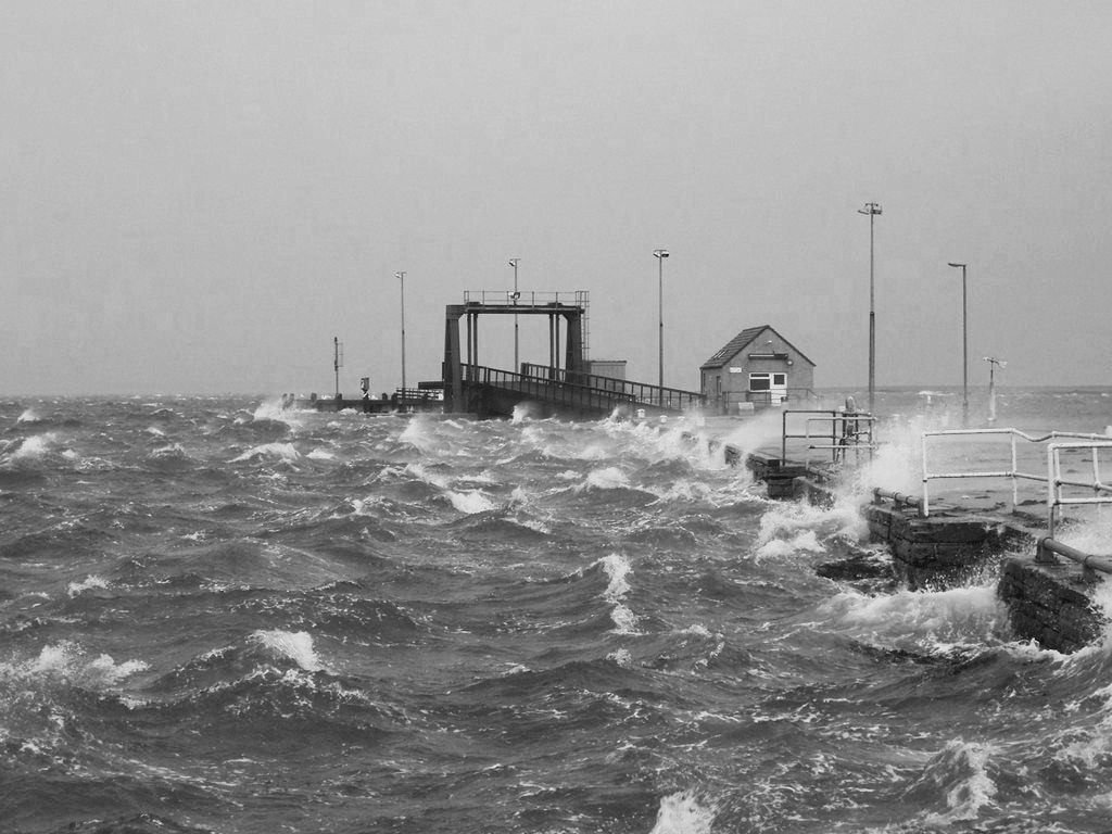
Sea storms are the most feared threat to Whitehall. People are usually prepared, nevertheless the damage is often heavy.

Things seem to get worse in recent years.

There is a landing strip on Stronsay for small planes, but it is by ferry that people in Stromsay have most contacts with the outside world.


Some links:
Craftship Enterprise:
http://www.craftshipenterprise.co.uk
Stronsay Fishmart Cafe & Hostel
http://www.stronsayfishmart.uk
Airy Fairy
http://www.airyfairyonline.co.uk
Stronsay Limpet
http://www.stronsaylimpet.co.uk
Orkney Star Island Soap & Textiles
http://www.orkneystarislandsoap.co.uk
Storehouse B&B.
http://www.storehousestronsay.co.uk

Yes !
