Tuesday 31 December 2013

Hello, Antarctica ,
Happy New Year !
there at 63.8 S, 155.22 E

That's where the MVAkademik Shokalskiy is trapped in the frozen sea, few miles north of the antarctic base Dumont D'Urville:


Three icebreakers were successively unable to rescue the russian ship, itself built in Finland in 1982 and "fully ice-strengthened " for arctic and antarctic seas.

After the failed attempts of one chinese and one french middle-class icebreakers to reach the Shokalskiy, a stronger and powerful australian ship, the Aurora Australis, was called from Casey, where it was anchored for the usual summer supply, to help release the russian / australian team and crew:


But no ship is prepared for zero visibility. A dense blizzard stopped the Aurora Australis just after it entered the frozen seas, some 10 miles from the Shokalskiy. No rescue could be done in such conditions.


Too thick, damn !

Ah, technology. But yes, there are other means - helicopters can at least rescue the scientific team and some tourists aboard, leaving the crew to maneuver as the ice recedes.

At least, they are having some fun in the antarctic Summer:


Treading on the ice to level a helipad. 

What an unexpected Ultima Thule there!

-------------------------
The End:


Thursday 26 December 2013

Ulaan Baatar, Mongolia:
absolutely-not-Ultima-Thule, but a frequently visitor here !

No-ultima-thule-at-all. I'd say this is even the anti-ultima-thule !
-----------------------------

Strange, unbelievable statistics from 'Blogger', show I receive continued visits from such an impredictable, remote and continental place as  Ulaan Baatar (or Ulan Bator), the capital of Mongolia.
I don't get it! The visit spot on the blogger's visit map never turns off.

Several other remote and amazing locations come and disappear, make ephemeral visits - and  make me so happy. But Ulaan Baatar is on the visit map to stay, always present, without a break. Do I have many followers out there? But after all what is there like ?

A nice 'Yurt' in central Ulaan Baatar.

Gandan, a budhist temple, the dominant religion. Some of them can be found in town, trapped between skyscrapers.

My amazement led me to do some research; and here I leave the results now.
*
Ulaan Baatar has a population of over one million people, which is amazing for what may well be the most interior capital of the world, far from the sea like no other. With an area of 1.5 million km2, Mongolia is a huge country, almost the size of India. However it has a population of less than three million, of which more than a third living in the capital - not the imperial capital of Genghis Khan, the ruined Karakorum, but the modern capital Ulaan Baatar.


The History of Mongolia was epic and grandiose. The fascinating Mongol Empire was as extensive as the Roman, and encompassed from the Baltic and the Danube to the Pacific, a large strip of territory diverse in civilizations and peoples. I can't even imagine how it was possible, during our Middle Ages,  so thriving a civilization on Europe's doorstep. The Pax Mongolica assured in the 13th century intense transcontinental trade routes across Eurasia. As expected, after the climax at the end of the century, the Empire finally collapsed and ended in 1368.

An animated vision of the Mongol expansion here:
http://en.wikipedia.org/wiki/File:Mongol_Empire_map.gif

That glorious past under the Khan dynasty faded to nothing but an almost deserted territory in the middle of nowhere, far from everything, underdeveloped and poor, stuck underneath Siberia, with a population of nomadic shepherds and a few villages in an isolation that only air flights and the Trans-Siberian helped to endure.

Steppe, Gobi desert and mountains - an unforgiving territory.

After the country's independence, a sudden wealth source was found in intense exploitation of coal, gas and minerals: huge deposits of copper, lead, gold, tungsten, uranium, all known of  the Soviet regime but carefully kept in secret!

Open-pit mine, one of many.

The profits mostly go to Rio Tinto,  some local business magnats, and what's left goes to favour the trade balance; Mongolia looks reborn in modernity.

Motorway into the capital. Like anywhere in Europe.

Sukhabatar square, the civic center. Under the central colonnade, a huge statue of  Genghis Khan, the beloved national icon.

The historic icon.

 A new icon.

If land doesn't allow farming or pasture, at least it delivers energy and high valued mineral rocks - a precious gift. As for pastures, they were mostly consumed by the goats, traditionally herded for the famous Altai Cashmere, which despite the crisis remains famous and a relevant export, an exquisite and unique product.


'Altai Cashmere':
http://mcashmere.com/brands/altai-cashmere.html


This new Mongolia of fertile subsoil, excavated and mostly deserted, leaves the nomadic life in the yurts, and starts to build skyscrapers, airports, shopping malls, pedestrian streets with fountains and terraces.
Famous brand shops. Luxurious hotels. Even the sad prefabricated 5-floor blocks of the Soviet era are converted: with Greek columns at the door, here a pub, there a hairdresser, a mobile phone shop. Nothing of this is really new: just enthusiastic capitalism.

Peace Avenue, the largest in Mongolia, centralizes almost all trade and can be a traffic and pollution hell.


Hotel in Ulaan Baatar

Hotel in Karakorum, the old historic capital of the Empire.


Surreal.

Two worlds coexist, in sharp contrast, and Mongolia is one of the most unequal and polluted countries on the planet.

A 'Ger' (yurt campsite) in an outskirt neighbourhood. With car by the door.

Two cities.

Winter is still the worst, people may have to survive by -50° C. Yurts are heated by coal stoves, the cheapest, and smoke becomes unbearable - you can't even see the other side of the street.

*

A post-modern Yurt .

You will be always welcome, dear  Mongol visitors, from your yurts or from your 15th floor lofts with a view.


----------------------

GDP growing 17.3%  ! (2011) 
GDP per capita $ 5 000 

Fotos: Panoramio, Skyscrapercity


Monday 16 December 2013

Invercargill, the last great city of the south

This is quite remote, though not arctic or antarctic; anyhow I see it as an extreme south 'Thulean' city.


Invercargill is the southernmost city in New Zealand, and in the whole Asia-Pacific region, around the same latitude of the Kerguelen Islands.


It lies in the heart of the wide expanse of the Southland Plains on the Oreti river's estuary, amid rich farmland, and is the commercial center of New Zealand's Southland region.

The Oreti flows southwards to the Pacific, through fertile flat lands.

The town center, the large Dee and Tay avenues, the Water Tower at left: built on flat land, it strangely reminds of  arctic canadian and alaskan towns - most buldings are just two or three-storey high.

Coordinates:  46° 24′S, 168° 20′  E
Population:   ~53 000

Bank Corner, the traditional town center

The Bank of New South Wales

Bank Corner is the intersection of Tay and Dee streets. In the middle of the roundabout is the Trooper's Memorial which honours those who died during the Boer War in South Africa.


When the commercial area moved some blocks away, the banks closed. They remain as remarkable architectural works and testimonies of an era of economic boom.


Built in 1878, the Bank of New Zealand is now the Bethel Centre, a Lutheran social organization.

The National Bank of New Zealand, on the Crescent, is now an Art gallery.

Many streets in the city, especially in the centre and main shopping district, are named after rivers in Great Britain, mainly Scotland: Dee and Tay, Tyne, Esk, Don, Thames, Mersey, Ness, Yarrow, Spey, and Eye rivers.

Dee street

The corner of Dee and Tay.

The 'Briscoes' building, 1880, one of the oldest stores in town.

The Alexander Building, on Dee street: late victorian style from 1901

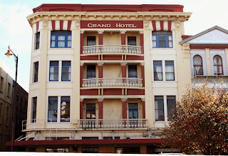
The Grand Hotel, from 1913, with cast iron balustrade balconies.


Tay stret


The Town Hall and Theater, from 1906, where the town's cultural life takes place.
The theater auditorium can accomodate over 1000 spectators.


The Crescent

In this short curving street by the Bank corner is located the glorious Victoria Railway Hotel, from 1896 , with an octogonal turret and ornate balustrades:

Also in this building is the exclusive Gerrard's Restaurant
http://www.hotelinvercargill.com/

Esk Street

The home of the Southland Times newspaper, from 1908


Esk Street is the main shopping street of Invercargill. The west end of Esk Street is anchored by the new Wachner Place.

Spring time on Esk street

Wachner Place is the new comercial and civic open area, with pedestrian streets; it has become a place to sit and people watch.

Invercargill umbrella, a modern town's landmark on Don street.

Modern architecture, cafés and leisure facilities in Wachner Place.

The Water Tower:

Completed in 1889, it is 42.5 m high.

The Southlands boys high school:


St. Mary's basilica:

A catholic church on Tyne street, the basilica was completed in 1905 in the late Victorian style.

St Mary's Basilica is another one of the more notable landmarks of the city.

First Presbyterian church:


In polychrome brick, from 1915, after italian romanesque style.


Invercargill Civic Theater at night:


http://www.icc.govt.nz/ServicesA-Z/CivicTheatre/Theatreinformation.aspx

Aurora Australis (Southern Lights) are frequent over Invercargill, mainly around the equinoxes: