Thursday, 14 October 2010

Inuvik on the Mackenzie delta, Northwest Territories (NWT) of Canada


Inuvik is located on subsea permafrost, on the East Channel of the Mackenzie Delta, approximately 100 km from the Arctic Ocean and 200 km north of the Arctic Circle.

The Igloo church and the Inukshuk, ex-libris of Inuvik

INUVIK (pop. 3500) is the largest community in Canada north of the Arctic circle.

Coordinates 68°21′N, 133°43′ W


Inuvik
is nested between the treeless tundra and the northern boreal forest, and overlooks the incredible maze of lakes and streams of the Delta.


Due to its northern location, Inuvik experiences an average of 56 days of continuous sunlight every summer and 30 days of polar night every winter.


Mckenzie Road is the main central street, where commerce and services are settled. The Eskimo Inn and The Mad Trapper restaurant are local favorites.


Lined with northern souvenir and gift shops, retails stores, businesses, as well as a variety of coffee shops, pubs, and restaurants.


A good collection of magazines to look through, summer or winter


The post office:

The residential area:

Colourful and joyfully styled housing contrasts with the surrounding tundra or with snow in winter:


The Alexander Mackenzie school:


The "Northern Images" store:


a native craft shop


Inuvik's Community Greenhouse, another landmark:


The most northern greenhouse in North America, and the only one of its kind in the world (converted from an old arena)!


The famous Igloo Church:


Inuvik's Our Lady Of Victory Church, often called Igloo Church, is a well-known landmark in the region. It is the most-photographed building in town.


The new Hospital:

A new hospital opened in early 2003, providing service to an area extending from Sachs Harbour on Banks Island, to Ulukhaktok on Victoria Island.


The Midnight Sun Complex :


A modern multi-use facility that offers recreational activities, like the Family Center:


The Mackenzie delta

The East Channel of the Mackenzie River flows to the Beaufort Sea and Arctic Ocean. In the winter, the Mackenzie turns into an ice road which allows for road travel to Aklavik and Tuktoyaktuk.


The Mackenzie spreads into a vast delta, Canada’s largest fresh water delta, close to the Arctic Ocean, in which the Peel River joins, splitting into thousands of channels before finally flowing to the Beaufort Sea.


The Dempster Highway


Inuvik is the end of Dempster Highway which connects connects the Yukon region to Northwest Territories on the Mackenzie River delta.


During the winter months, the highway extends another 194 km to Tuktoyaktuk and Aklakvik on the northern coast of Canada, using frozen portions of the Mackenzie River delta as an ice road .

The Dempster Highway at the Arctic Circle crossing.

----------------------------
see also: Tuktoyaktuk

Thursday, 30 September 2010

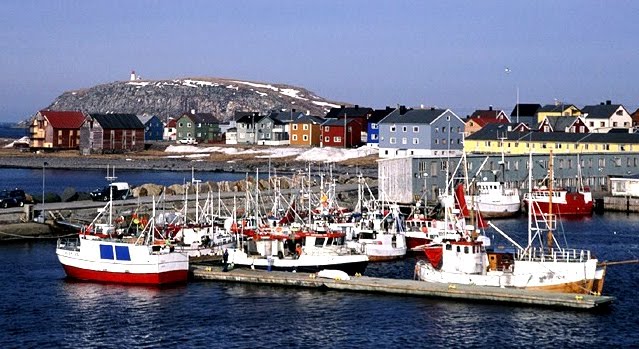
Vardø, Norway's arctic fronteer


Vardø (pop. 2 600), facing the Barents sea near the russian border, is the easternmost town in Norway - east of Saint Petersburg and, strange as it may seem, east of Istanbul !

Location: 70° 21' N., 31° 02' E.

The port of Vardø, on the Barents Sea, remains ice-free all year round thanks to the effect of the warm North Atlantic drift. 


The rich fishing stocks in the sea around are the main reason for the town's existence. Fish processing plants and a rapidly-expanding tourist trade provide the primary sources of employment.

The town is also the northern termination of European route E75.


In August 1944 the allied bombings destroyed many of the old buildings and the town was almost entirely destroyed by fire. Nevertheless, there are many buildings which escaped the wrath of the flames. Vardø is home to North Norway's largest wooden building, the old primary school:


Another wooden landmark is
the home of the Chief Justice, built in 1919:


Vardø also is the most northerly fortress town in the world and the only town in Western Europe which lies in the arctic climatic zone. It is also the oldest town in northern Norway
The Pomor Museum, http://pomor.no/

Vardø's major attraction is the Vardøhus Festning, a fortress dating back to the late 13th century (although the present structure dates from 1734).The fort is an octagonal, star-shaped fortress built in the period 1734-1738.


Vardøhus Festning is home to two rowan trees which are carefully nurtured and warmed in winter since these trees cannot normally survive in Vardø's cold climate, north of the Arctic tree line. Originally, seven trees were planted in 1960; the one that survived managed to blossom twice, in 1974 and 1981. The tree finally succumbed to cold weather in 2002, but two new saplings have been planted in its place, at both sides of the officer's quarters entrance stairs.


The fort's garrison salutes the returning of the sun after the long arctic night with two shots every year. This is to mark the end of the Arctic winter darkness. Then students at the Vardø schools can leave for the rest of the day.
Vardø is a port of call on Norway's Hurtigruten ferry service.

Monday, 20 September 2010

Olonkinbyen, pioneer town for the XXI century


Olonkinbyen is a settlement on the Norwegian island of Jan Mayen, a XX century prefabricated arctic base in a desert island.
Olonkinbyen houses the staff that operates the weather station and the radio station. Currently there are 18 members stationed in Olonkinbyen who make up the entirety of the island's population, therefore making it the "capital" of Jan Mayen.


Jan Mayen is an integrated geographical body of Norway. Since 1995 it has been administered by the county governor of Nordland; however, some authority has been delegated to a station commander of the Norwegian Logistics Organisation-CIS, a branch of the armed forces.
Notice that Jan Mayen island is Europe! The mid-atlanic ridge crosses there - therefore the volcan - but the Jan Mayenians of Olonkinbyen are European.


Teams change every 6 months: an Hercules C 130 takes care of the transport, the airfield is safe. On the contrary, the sea coast is savage with very few points for landing in safety.
These planes fly to Jan Mayen from Bodø, it is a 1000 km flight of 2 hours. They also bring supplies and mail, but there is only 8 flights each year, so letters from home are scarce. On Jan Mayen there is a 1.5 km landing strip of gravel, used for the scheduled C130 landings, but also for other missions like ambulance planes to collect sick or injured fishermen.

The team in Olonkinbyen is mainly from Norway. They live in a complex of interconnected climatized containers studied for isolation and resistence and decorated inside as much as a small hotel as possible, with lots of labs and working offices; as for comfort, there is a media room, a library, a museum, even a swimmimg pool !
Interior: Room
Interior: corridor
Interior: museum
Interior: post office
The crew runs the navigation and meteorological stations and maintains the infrastructure - airstrip, power station, buildings.
airport building
As for visits, just some cruise ship in the summer, a polar bear comes now and then, and they have old cabins from the first settlers (fishermen) restaured for logging, mostly for scientific teams.