Monday, 11 April 2016

Stokmarknes, Vesterålen, Norway - a 68º N wealthy Thule.


The eastern coast of Norway is one of the probable Ultima Thule sites, meaning the farthest place that the Greek sailor Pytheas reached in his northerly (arctic?) journey around 325 BC. From his and other later accounts, he may have gone as far as 65º to 70º N. I wrote several posts here on the subject, but none on Vesterålen, an achipelago north of the famous and outstandig Lofoten Islands. One of the Vesterålen islands is Hadsel (Hadseløya), a small mountainous and rocky island with two towns and a few hamlets on its coastline. Latitude 68ºN - right on the spot !


The most populated is Stokmarknes, also a tourist destination daily visited by the Hurtigruten Express and because of the wonderful nature landscapes nearby. It's not that easy to access, though - on a small island of an arctic archipelago off the northeastern coast of Norway, and known for its raining weather.


The lush vegetation at 68º N (220 km north of the Arctic Circle) comes as a surprise, but in fact the treeline limit barely touches Norway - just a small northerly treeless patch around the North Cape.


Dalsvatnet, a small lake.

High mountains with deep valleys and lakes between make for a much forested but wild alpine hinterland.


On the southwest coast, the best sandy beaches, small jewels completely off the beaten tracks !


Stokmarknes

Coordinates: 68° 33′ N, 14° 54′ E
Population: ~ 3700


Stokmarknes sits on the northern coast of Hadseløya. It started mainly as one more fishing village, but is now upgraded to "Hurtigruten's birthplace" town: here in 1881 was established the small Vesterålen Steamship Company, predecessor of Hurtigruten. A museum was built dedicated to the History of the coastal express.

Rorbuer cabins, part of the Crystal Hotel, with a view to the Hurtigruten Museum.

Rødbrygga, the pub and pizzeria where people meet for a drink.

Stay 'al fresco' in summer is a must.

Markedsbrygga, previously a wharf.


Markedsbrygga, the Market Wharf, is now an outdoor clothing shop plus convenience store, café and small theater; also, the local Tourist Office.

Markedsgata is the only shopping street.

'Aktuelle', in a green wooden house, clothing.

Trykkeriet sells anything, from mobiles to houseware, teas and cakes.

'Galleri Apotheket', a collective gallery for local artists.
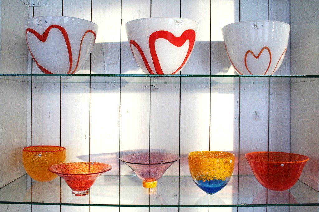
Glass pottery and ceramics, photography, painting, sculpture and small crafts.

The awarded public Library, good architecture.


Another excelent improvement, the new Vesteralen Hospital (Sikehus).


The Hurtigruten coastal express

A Hurtigruten ship passing under the Hadselbrua (1978), the curved bridge.

If one compares a town like Stokmarknes, in wealthy european Norway, to any town at the same latitude at, say, Alaska, Canada or Siberia, the differences are immediatly obvious. Yes, this is 68º N Arctic, but with all the benefits and comfort of civilization and healthy economy, plus daily ship connections. Remoteness is not a burden here. If you search severe arctic harshness, you must search elsewhere, like Inuvik in the previous post, Point Hope in Alaska, Verkhoyansk in wild Siberia.

Part of Stokmarknes developpment as a lucky arctic town is surely due to the Hurtigruten company.


The Hurtigruten Museum

A waterfront view: the Finnmarken ship-museum, Rødbrygge and Markedsbrygga.

The first coastal express, the steamer 'Vesterålen', sailed in 1893; Stokmarknes was its homeport and home to its founder, Richard With.

The Vesterålen steamship.

For more than 100 years, Hurtigruten has been an integral part of life in northern Norway, tying cities and communities together, carrying goods and people over the nations number one highway: the ocean. The town's pride steamer Finnmarken was taken ashore for the Hurtigruten museum in 1999.

The M/S Finmarken on service.

The radio cabin of the Finnmarken.

The M/S Finnmarken served the express route from 1956 to 1993, and after a definitive pane was given as the world's biggest museum artefact.

But the Vesterålen Cultural Centre is larger than the Museu; it has a modern stage for opera, theatre and concert performances.

What eles? A movie theater? Yes, of course, a regular movie theater, the Kino is also part of the Hurtigruten Hus in Markedsgata:


Hadsel Church

The historic Hadsel Church is located about 5 kilometres east of Stokmarknes, perched on a hill overlooking Hadsel fjord.  The wooden octagonal church building was constructed in 1824, but its altarpiece from 1570 came from an older church. This was once an ecclesiastical centre since the Middle Ages.


The polychrome altarpiece is Dutch (16th century).


-----------------

Maybe Stokmarknes is a bit far off, too small and often under bad climate. But apparently nothing important is missing, the old is counterbalanced by the modern, town city life is surrounded by nature and landscape. For an arctic little town, it is a rich and attractive one.


Monday, 28 March 2016

Inuvik and Iqaluit, tale of two cities: Canadian arctic from east to west


Iqaluit and Inuvik are the two main Arctic Canada native towns, from where most frequently I have visitors coming here to my Ultima Thule. That's the reason why I'm posting this - to thank those towns as regular visitors.


They are as far from each other as 2855 km in longitude. It's like Oxford (UK) to Moscow, all the way across Europe ! By plane it takes at least 24h , three to five stops, between them. No roads, of course, but if you are some John Rae you can walk or dogsled in good weather before he ice melts - that will take you several days through inospitable but wonderful tundra scenery and be the adventure of your life!

I posted about them before, but always something is left to say.
- link to Inuvik
- link to Iqaluit


INUVIK, east NWT

The Dempster Highway is the only road connection to Inuvik, from Dawson City in Yukon.

Though not ideally paved, it is the only one to Inuvik, and magnificently scenic also.

Inuvik may have some alpine look, rather odd on flat tundra.

At 68º N (200 km north of the Arctic Circle) on the west tip of the North West Territories, Inuvik sits on permafrost, inland but close by the large Mackenzie delta, and reaches a population of about 3500. It's like NWT's capital town. It has still a short History, since it's foundation in 1953.
The name Inuvik means 'place of man' in Inuit.

Downtown Inuvik: during the Christmas Season.

Downtown Inuvik: the Igloo Church.

Café Gallery on Mackenzie Road; outdoor seating in Summer !

Most houses are wooden built on stilts, above the permafrost and with double-panneled walls for insulation.


New buildings ad colour and comfort.


The Community Greenhouse is the most beautiful and successful project in town. There is no other as northerly in North America and probably the whole world (I'm not sure whether Longyearbyen, Svalbard, has one). The first hydroponic crops happened in 2000 and were sold to the community.


Spinach and lettuce grow very well with multiple yearly crops. Tomatoes, carrots, peas, herbs, strawberries, rhubarb, are among the common crops.

Flowers abound, and rarer crops include cucumbers, raspberries, roses, and even watermelons ! We are at 68º N, again note, 200 km north of the arctic circle: what a precious luck to take advantage of such a greenhouse !


But flowers grow in the tundra too: spring by the Dempster Highway is a must:


The Tree Line


Inuvik sits on the tree line too.


The territorial limit for trees to grow (dashed line on the map) waves up and down in NWT and really close to Inuvik some sparse little forests resist which are an unbelievable joy to see at this latitude.


A beaver seats in the sun, resting from the building hardwork.

One of the greatest sights is the river Mackenzie crossing by reindeer herds, sometime as big as 3000, now driven by herders on snowmobiles.


The event is announced and has a large popularity. Just inforgetable.


Reindeer Station, an old cabin for herders to rest after the exhausting work, is now restores and open for hot drinks !


Aurora over the tree line.


------------

IQALUIT, Baffin Island, Nunavut

The Legislative Assembly of Nunavut, Iqaluit's most important and iconic administrative building.

The main junction and busiest part of Iqaluit, where 'Queen Elizabeth II Way' and 'Federal Road' cross 'Mivvik Street'.


Iqaluit, at 63º 44', is located on the east coast of Baffin Island, Nunavut. With a population of 7 100, unusual a this latitude, it leads Nunavut as its Capital town.

The town center: bank, finance, hotel.

Although that latitude is sub-arctic, the climate is harsh arctic, and the town frequently reaches lows down to -50 º C, meaning everything closed and no flights. The proximity to the very cold eastern Baffin Bay currents, between the North Atlantic and the Arctic Ocean, explains all that bad weather. The town also sits on permafrost, a limitation to high building and a need for piles or stilts to elevate houses from the soil.

Moving around: few cars, snowmobiles reign on the streets.

Iqaluit has public transport like any middle size town.


The new Quilaut building, on Mivvik Street, with native art decoration.

A new Aquatic Centre with swimming pools is also expected to open in 2016.


Due to the shore's shallow waters, only flat bottom vessels like Canadian Guard's Eckaloo can dock at Iqaluit.


Iqaluit's History started in 1949 when the Hudson Bay Company (HBC) installed an outpost at Frobisher Bay, as Iqaluit was then known. Later, in 1942, an airfield, base and a radio station (part of the DEW line) added strategic importance. The improvement of the airport was the stronger factor of economic and administrative growth.

Only recently, in 1987, did the town change its name to Iqaluit, as the Inuit called it - 'place of many fish'.

The airport, pride of Iqaluit, is practically the only connection door to and from the city. Not a single road enters or leaves town, and no ferry sails from Iqaluit. Yet. Serious studies for a deep water harbor allowing ferry connection are under evaluation and that is a high hope for the city's development.


A glorious almost-midnight sun.

Flights connect to Ottawa, Yellowknife, Montreal, Edmonton and other smaller airports on Baffin Island.

Nunatta Sunakkutaangit Museum


The Nunatta Sunakkutaangit Museum houses a large collection of Inuit and Arctic artifacts and art. It's near the shore, in a white and red building, part of which is a HBC restored house.


Some great Inuit Carvers lived in Iqaluit, as is the case of Jackoposie Oopakak. His famous serpentine Falcon has been present in several exhibitions:


No trees here at Baffin Island, the long extreme cold season not allowing. The treeline is quite further to the south. Only small arctic plants, shrubs and lychens.

Anyhow, Iqaluit does change with the seasons !

The long long nights of Winter...


Glorious spring...


And almost-midnight sun in Summer...

Fishing at Frobisher bay's calm waters.