Wednesday, 7 September 2016

Napakiak and Napaskiak, both on the west coast of Alaska near the Kuskokwim river delta.


This is the Arctic in a less refined mode, two settlements under the minimum decency and quality of life I've most oftenly showed here. For example, Napakiak does not have a piped water system - a striking contrast to the previous Solvorn post, but hey!, that's Norway...

Alaska - as well as Russia - has a lot to improve, mainly in its native villages and towns, to reach the living levels of other northernly regions elsewhere, mainly in Europe or Canada.

But anyway, one can always feel attracted to the high latitudes, to this northern landscape and lifestyle, and truly some improvement has been done. Let's have a look at the sub-arctic region of Bethel, by the Kuskokwim River, the second largest in Alaska after the Yukon River.

The Kuskokwim River flows westwards through southern Alaska to the Bering Sea. Both Napakiak and Napaskiak are located near its broad estuary.


Napakiak


Coordinates: 60° 41′ N, 161° 58′ W
Population:  ~ 350


Napakiak is located at approximately 16 km downriver from Bethel, sitting on a lowland sandbar on the north bank of the Kuskokwim River. The Yup'ik Eskimos have lived in this region since 1000 A.D.


The sand island on which the village was built is severely eroding, and is prone to frequent and severe flooding due to ice jams and overflow.


The village looks well kept. Most of the houses look as if they were recently painted.


A native-owned cooperative store opened in 1946. A Post Office was established in 1951. The National Guard post was built in 1960, and the first airstrip was completed in 1973.

The Post Office.

There are presently two stores in Napakiak:

Jungs Trading post

Naparyalruar native store.

Traditional fishing is an important aspect of life in Napakiak; there are about 12 vessel owners. Salmon, sheefish, whitefish and lamprey abound in the nearby waters. Moose, bear and seal hunting provides meat.

One clinic - not red, not blue, a rarity.

No roads lead from/to Napaskiak ! But the river road is frequently used by Napakiak residents:

Boats ashore and one other returning, on a river canal.

Sunrise on the Kuskokwim ice-road to Napaskiak. In winter, the marked ice trail allows ATV and snowmobiles to reach Bethel.

A small plane on Napaskiak gravel stripe - and at far you can see trees, in fact the tree-line is not far, some 22 miles to the Northwest.

The isolation caused by the absence of roads is partly compensated by daily flights to other Alaskan towns; a flight to Napaskiak takes just 10 minutes ! ...


Napaskiak

Coordinates: 60° 42′ N, 161° 45′ W
Population: - 420

Napaskiak is another traditional Yup’ik village just 20 km east of Napakiak, on the oppostite east bank of the Kuskokwim river, seven miles southeast of Bethel, the region's main settlement.

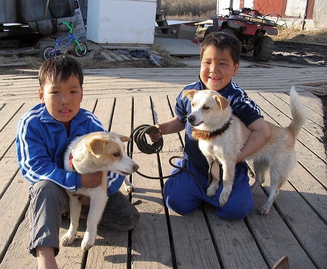
To move around the village only a rather well-maintained wooden boardwalk serves most houses.


There are no roads to or in Napaskiak (except winter ice-road), and there is also no running water ! Boardwalk connects everywhere - no streets or even house numbers, just slightly raised wood boards over the permafrost.


The school, local businesses and fisheries provide employment while subsistence activities (traditional fishing and hunting) supplement cash earnings.

Approximately 150 students attend Napaskiak's School.

Houses are raised on stilt-like beams of wood to be sturdy against the permafrost and rainwater. And so are too the school or the old orthodox church.

St. James orthodox church.

The entire (?) village is Russian Orthodox.


Residents have access to healthcare and shopping through short flights or boat travel to Bethel. There is a gravel airstrip and seaplane landing area that provides flight access year-round.
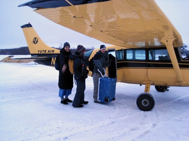
Boarding to Bethel.


The Yukon-Kuskokwim rivers Park


The Kuskokwim river is a large river in Southwest Alaska. Its basin and its flow volume are quite remarkable. The name come from a Yup'ik word kusquqviim meaning 'big slow moving'.
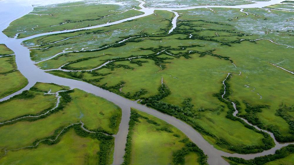
Kuskokwim basin near the mouth, drainig to the Bering Sea. A maze of small side-rivers converge through the tundra to the main flow.

Marshes in Kuskokwim's delta.

The southern portion of the Delta is a huge, swampy, treeless area comprising the muddy lowlands where two rivers (the Yukon and the Kuskokwim) drain into the ocean. A rich fauna - birds and fish, mainly - lives there.

Spectacled Eider (somateria fischeri), one of the beauties in the Yukon-Kuskokwim Park.

White-fronted goose, also a common visitor to the Kuskokwim's marshes.

A lonely barge navigates on Kuskokwim's final estuary.

Sunsets by the Kuskokwim are famous.


Monday, 22 August 2016

Solvorn, the prettiest village in the Sognefjord - and Urnes Stave church just across.


Solvorn is a tiny village located on the western shore of the Lustrafjorden, in Sogn og Fjordane, Norway. Solvorn sits directly across the fjord from the village of Ornes, place of the precious 12th-century Urnes Stave Church.


Solvorn
Coordinates: 61°18′ N, 07°14′ E
                   (sub-arctic)
Population:  ~ 230

The fjord waterfront of Solvorn.


Solvorn has a long history as a trade center, with a church, a courthouse and a harbour serving the people who lived around the lake Hafslovatnet and its surrounding villages.  Solvorn received a post office in 1841, which was recently closed in 1995.

Most houses are painted red or white, as usual in Norway's arctic and sub-arctic latitudes.


Many of the houses date back to the late 19th century. Presently, Solvorn has a church, a store, school, hotel and café. There are a couple of farms but the majority of the population is working either in the tourist industry or elsewhere in the region.


Picture postcard main street.


The charm of Solvorn - colourful wooden houses with fenced gardens with a view to the fjord.


A small green yard, then a boathouse, opening to the bay.


Along the beachfront, the boathouses were owned by local farmers and merchants, who took their products by boat to towns and markets around the fjord.


Some of the wooden red painted boathouses are newly restored.


The Wallaker Hotel


Solvorn is home to the historic Walaker Hotel, a classified house dating back to about 1650. 


The rooms are also finely decorated to feel centuries old - though with all modern amenities.


A magnificent garden overlooking the fjord.

The romantic gazebo in the garden.


Linahagen Café


A combined grocery shop and café, the only 'urban' public place where you can buy goods, meet people and have tea or coffee and a cake.


There has been a regular ferry route from Solvorn to Ornes, across the Lustrafjorden, since 1859. The beautiful crossing is a must before the visit to Urnes church.


Urnes Stave church


The wooden church of Urnes dates back to the Viking age (c. 1130), in transition to Chritianity, and is the oldest one of its kind.


Stave churches constitute one of the most elaborate and advanced wooden buildings in North-Western Europe during the Middle Ages.


The wood carving decor of exquisite quality on the outside includes elements of Viking tradition from the 11th century.


Wood carved pannels: above, a snake curling upwards being bited by another animal, probably illustrating a theme of norse mythology.


Deep into de fjord, the night comes down softly in the late hours of Summer days. Tranquility reigns in the small village of Solvorn.