Monday, 23 March 2015

Livingston Island, South Shetlands:
Spain and Bulgaria in close neighbourhood


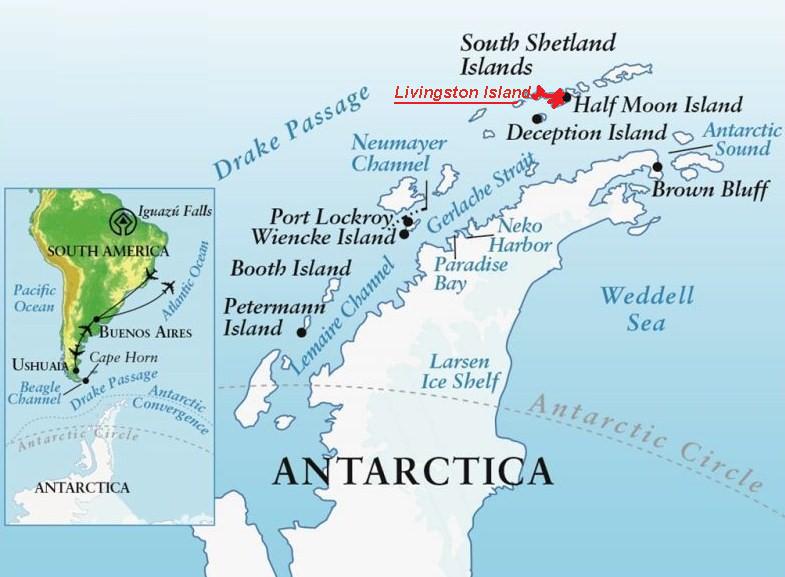
The islands and islets along the west coast of Antarctic Peninsula, on the tumultuous waters of the Drake Passage, are home to a number of stations from several countries, making this the most densely populated part of the continent, despite being still an immense desert of ice and rock.

One of the South Shetland islands has been chosen by two nations - Spain and Bulgaria, two distant European countries - to build their stations in close vicinity: Livingston Island.


Livingston Island is the second largest island in the South Shetland archipelago. Its irregular shape is 73 km long for 5 km (min.) to 34 km (max.) wide.

Coordinates: 62° 36′ S, 60° 30′ W

Hannah Point, the west point of South Bay.

Ice cliffs, sharp rocky peninsulas, beaches, coves and bays form most of the coastline. Except for isolated patches by the shoore, the land surface is covered by an ice cap, highly crevassed in some areas, with ice domes and plateaus and a number of valley glaciers.


In winter, temperatures drop to around -25º C, and in summer they rise to an average 2º C, when the majority of snow on site melts. Strong winds buffet the stations, often exceeding 160 Km/h.


The two stations, just 2.7 km apart (5.5 km route),  are located in Hurd Peninsula, facing South Bay and Hannah Point, in small ice-free strips by the shore framed by several glacier mouths. South Bay is a 12 km wide bay in the south coast of the island. The area was known before by whalers which used it as a safe haven.


Spanish Antarctic Base 'Juan Carlos Isits in Hurd Peninsula, 40 m from the shore.

Coordinates: 62°39′ S, 60°23′ W
Occupation: up to 24 places,
                      from November to Mars
                      (austral summer)


Inaugurated in 1988, the base was built using container modules and igloo-tent accommodation.


The recently renovated base comprises habitation and science units and a series of support modules for services and storage. The main building comprises three wings of accommodation arranged around a central core while the science building is a separate structure far enough away to provide a refuge in case of a major fire.


The main building provides accommodation for 24 people, with the option to increase the population to 48 in the future. The orientation of the buildings makes best use of the site topography, with windows framing wonderful views of the surrounding land and seascapes.

'Española cove', seen from up the hills behind - the station his hidden by the rock, where the arrow points.


Byers Camp (acampamento)
an extension of Base Juan Carlos I.


A mainly ice-free ground, Byers Peninsula forms the west end of the Island. On the south of the Peninsula, a large bay called 'South Beach' is the location of the camp.


It consists of two igloo-type shelters, one for eating and cooking, the other working as a scientific lab open to international crews.

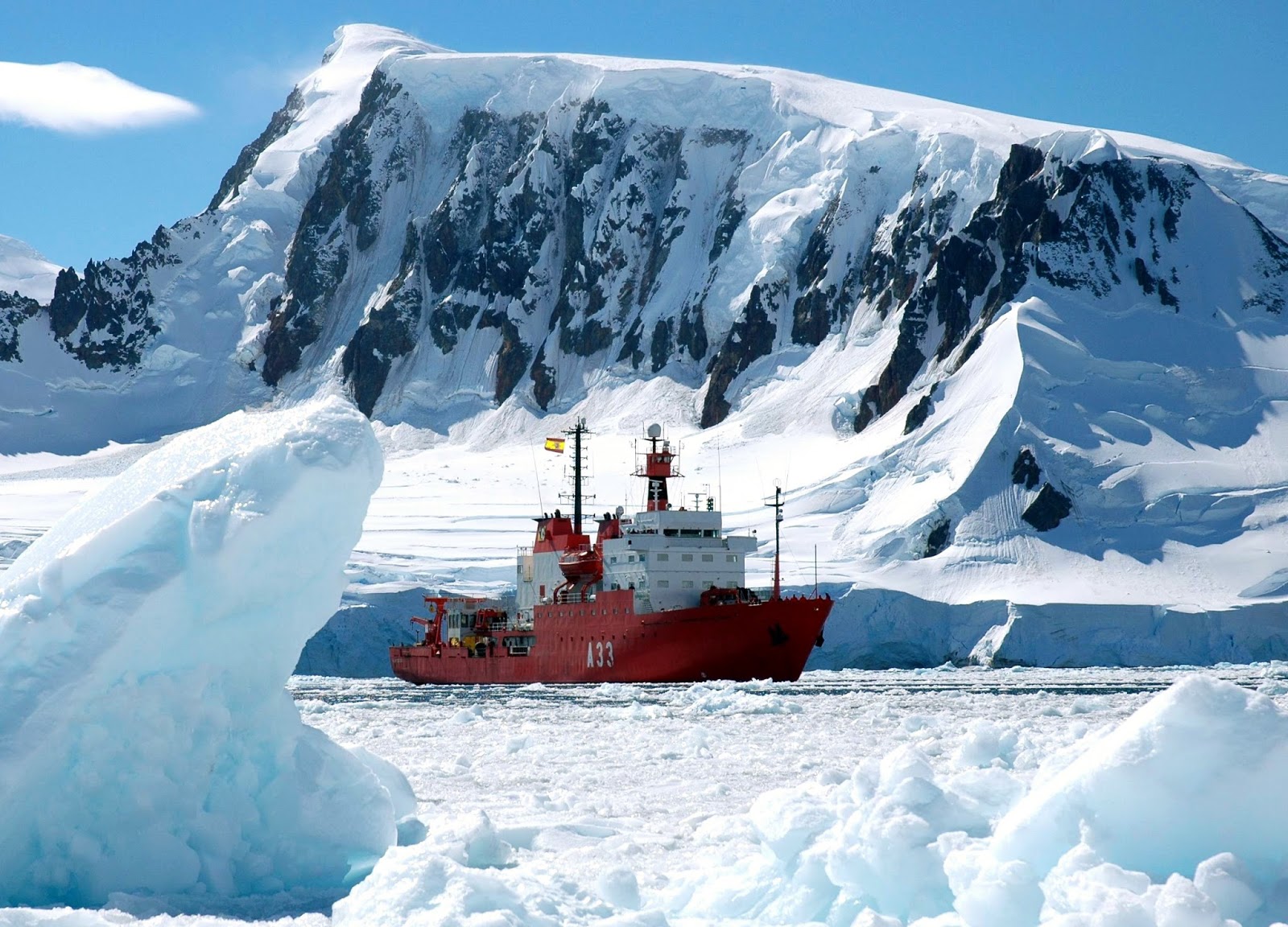
- Spanish Antarctic supporting ships -      (buques).

The 'Las Palmas' under bad weather in Drake Passage.

Buque Las Palmas was launched in 1978, the first ship to participate in the Spanish Antarctic campaigns. She has been later reinforced to navigate in iced waters.

The 'Las Palmas' is mainly as a logistic support vessel, while the more recent and strong BIO Hespérides (A33), prepared for ice-breaking, is dedicated to scientific work.

The Spanish Navy 'Hespérides' (1991), 2.830 tons, 82,5 meters .


Antarctic mail from 'Juan Carlos I ' base.

------------------------------------------------


The 'Johnson Glacier' flows between the two stations, and slides into 'Johnsons Dock', a kind of wide fiord.


The Bulgarian Antarctic Base “St. Kliment Ohridski (BAB) is less than 6 km North of the Spanish station.

Coordinates:  62º 38' S, 60º 21' W, at the Eastern Coast of South Bay.
Occupation:  ~ 25 people during the austral summer (November to March)


St. Kliment Ohridski Base (Bulgarian: База св. Климент Охридски) was named in 1993 for St. Clement of Ohrid (840-916), a medieval scholar, writer, priest and saint.


The main building was built in 1998 and is made of wooden panels; it includes living room, kitchen, doctor's office, storage room and two bedrooms. 

Under a snow storm.

Snow mobiles are welcome equipment for the scientific crew.

300 meters from the main unit is a metal sheet structure, which in summer is used for Orthodox chapel, and in winter for sled stocking.

St. Ivan Rilski chapel (interior), built in 2012.

The supplies and the transport of the Bulgarian crew are provided by the Spanish Navy ships.

---------------------------------------------

There are plenty of nunataks in Livingston Island. A nunatak is an exposed rocky peak of a ridge or mountain, not covered with ice, within an ice cap.


Helis Nunatak (Nunatak Helis) is a crown-shaped rocky peak located at 62° 32′ S, 60° 04′ W, in the eastern side of the island.

The peak is named after the ancient Thracian capital town of Helis, whose remains can be found at Sveshtari, Bulgaria.

Aheloy Nunatak

A rocky 390 m peak in central Livingston, right on the ice cap's Huron Glacier

Edinburgh Hill


Edinburgh Hill is a rocky hill of elevation 180 m on the east coast of Livingston, at Varna Peninsula by McFarlane Strait.


The area was known by early 19th century sealers and whalers.


An Antarctic sunset
viewed from the Bulgarian station.


Friday, 6 March 2015

Achill, an Irish Island with well-kept secrecy.


I have often reported here of places that are far south from arctic, but are remote enough to deserve a discovery by Thule sailors. That's the case of Achill Island, in the extreme west of Ireland, separated from the mainland island by a narrow channel. Landscape, imposing cliffs and sandy bays are Achill's main features.

Achill Island is the largest island off the coast of Ireland, more precisely the west coast. Its area is 148 km2, in a quite irregular shape.


The main villages are Keel (Keel an Caol), Dooega (Dumha Éige) and Dugort.


Achill is attached to the mainland by a bridge since 1887, between the villages of Achill Sound and Polranny; the current bridge was completed in 2008.

Crossing the Achill Sound to 'Oilean Acaill'.

The Post at Gob a 'Choire, the first village after the bridge.

Coordinates: 53° 58′ N, 10° 02′W
Population:  ~ 3 000

Achill Island (Gaelic name Oilean Acaill) has a long history of human settlement, with megalithic tombs and promontory forts dating back 5000 years. From the 15th century, a fortified tower house - Kildamhnait Castle; from the 19th century the deserted village at Slievemore.

Dugort


On the north side of Achill Island, Dugort is prized with two Blue Flag beaches: one at the foot of Slievemore mountain, the other more eastern Golden Strand, with sandy dunes and grasses.

Dugort Strand beach.


The Valley House


The Valley House sits on the former estate of the Earl of Cavan, who built it as a hunting lodge. Presently it is serving as a hostel with tearoom and bar.

The Yellow Lady tearoom, at The Valley House

A Hotel is also installed on the former Achill Mission, established here in 1839.


The legacy of The Colony also includes St. Thomas's church:


St. Thomas's church, Dugort


Slievemore, deserted village


Some 80 ruined stone cottages strech along a mile long on the southern slopes of Slievemore hill, either side of an ancient pathway, almost all aligned in the same north-south direction.


They date at least to the Anglo-Norman period (12th Century AD). The cottages were used as uphill summer dwellings by cattle herder families from downhill villages like Dooagh. After the 1845 famine, the village was abandoned because the only food available was caught from the sea.


The area is rich in archaeological artefacts, including megalithic tombs dating from the Neolithic period, about the 3rd or 4th Century BC.


Keem Bay and the cliffs of Achill Head.


Located at the western tip of Achill Island - and therefore one of the most westerly points in Europe - Keem Bay offers a breathtaking clifftop road, over a perfect horseshoe bay, with a sandy beach flanked by dramatic cliffs and at the head of a spectacular valley.


The Blue Flag beach at Keem is perfect with its crystal clear waters revealing a variety of fish and sealife.


The cliffs on the western side of the valley provide on of the most exhilarating clifftop walks in Ireland, stretching back to Achill Head.


On the eastern side, the slopes rise up to meet Croaghaun peak, up to 668 m, with Europe's second highest sea cliffs on its northern face.

Croaghaun cliffs

Achill's head, the island's eastern tip.


Keel


Keel (Keel an Caol) is probably the prettiest village in Achill, where several gabled two-storey houses remain from past centuries.


One of the few traditional houses remaining in the island.


Bervie guesthouse, splendid accomodation.

At Bervie, the hard boiled eggs come with a sweater !

Behive café, coffee shop and local crafts

Irish coffee and scone

Calvey's restaurant entrance.

You can also find in Keel one of the best galleries in the island - Western Light Art Gallery.


Dooega and the Atlantic Drive.


A little fishing village and beach on the southwest seashore, where the fabulous Atlantic Drive starts weaving along the coast.


The Atlantic Drive runs to the island's southeast by the Atlantic coast, winding along cliff highs and bay lows.


After Dooega, the road starts climbing southbound.

A 40km drive that includes the best of the Island's scenery.

Sheep, grass, rocks, and sea with a distant background.

The narrow road is also an extension of the cycling trail Great Western Greenway.


The Castle Tower at Kildavnet

The road then turns North and leaves the Atlantic behind; the most famous ex-libris of Achill follows after just a few miles. It is a fine example of a 15th Century Irish tower house.


Kildavnet (Cill Damhnait, Kildamhnait) is located on the south-eastern shore of Achill Island, overlooking the waters of Achill Sound.


Known as Grace O'Malley's Castle, it's associated with the O'Malley Clan, a ruling family of Achill.


Built about 1429, the Tower stands at a strategically important spot, guarding the waters of Achill Sound.


Parts of the present remains are thought to date from the 12th Century. Adjacent to the chapel is the ancient graveyard of Kildavnet, which contains many unmarked graves of 1845 famine victims.

Nearby, a small harbour for tourist boat journeys.


It is colourful.


And the surprise: Achill Secret Garden.


Hidden in a small bay on the island's east coast, you find the most secret public garden in Ireland, belonging to Bleanáskill Lodge, a peaceful oasis two miles south from Achill Sound. The garden is situated by the sea.


It is difficult growing anything in coastal gardens with the winds and the salty air, but through the past decades most owners of the lodge contributed in one way or another to the garden.


The garden is a paradise of colour, scents and sculpture. 


A haven of tranquillity and peace


Sunset in Achill's wild coast.