Wednesday, 24 February 2016

Cape Dorset (Nunavut), an art capital on the Arctic Archipelago, part I

-------------------------------
As I was writing this post, it became too long to publish in full just once. 
So I divided it in two, this is just a first part, in a few days the second part will appear.
-------------------------------


Cape Dorset Inuit: Kinngait, high mountains) is situated on flat ground at Dorset Island, close to Foxe Peninsula at the southwestern tip of Baffin Island. Surrounded by arctic landscapes, Dorset Island supports many forms of arctic wildlife, including herds of caribou or, sometimes, a wandering polar bear or two, and in Summer arctic wildflowers dappling the tundra valleys with vivid colours.


The Inuit settlement of Cape Dorset became well known for its modern community's outstanding artists: graphic artists, weavers, carvers, that have made the small settlement an Inuit art capital.

Cape Dorset sits on the northwest shore of Dorset Island, surrounded on one side by rocky hills and on the other by the Hudson Strait.

Most houses are improved containers or wooden cabins, carefully insulated from permafrost.


Cape Dorset

Coordinates:  63° 22’ N, 90° 51’ W
Population:    ~1300


People keep traditional life patterns, namely hunting and fishing as main activities.


The Hotel (above) and Northern store (below) are two small luxuries in town.


Recently a wooden red gazebo was installed at a view point; it is an unusual landmark for such a northern community, but they love it.


It was installed for residents to better enjoy the community and for visitors to mingle with residents. The scenery, overlooking the sea inlet and more distant mountains, is beautiful from every direction, there is enough room there for children and adults to be walking around outside.


View to the harbour at sunset.

Life in the far North flows slowly, marked by light and darkness, water and ice, remoteness and tradition.


Mallik Island


Mallikjuaq, just a few miles Cape Dorset, is an island of rounded rock hills and low tundra valleys, notable for hosting an ancient Dorset archaeological site. A thousand years ago, the Thule people lived on Mallikjuaq in low stone houses framed with whalebone ribs, which were roofed with hides and sod. The eastern end of the island contains the remains of nine winter houses with stone foundations still in place. Archaeological evidence indicates that earlier people from the Dorset Culture also inhabited the island for centuries before the Thule.

Dorset Culture ('Tuniit' or 'Sivullirmiut'):  500 BC to 1500 AD
Thule Culture (Proto-Inuit):                   
1000 AD to 1600 AD
Inuit Culture (Eskimo):                         
1600 AD to present-day


Tips of recent History

From the mid-19th century to the early 20th century, whalers and missionaries visited the area. In 1913, the Hudson's Bay Company (HBC) set up a trading post in Cape Dorset.


The settlement began to grow around it, Inuit people traded furs, tanned skins and ivory narwal tusks for supplies like kerosene, flour, tea and sugar. Between 1938 and 1953, Anglican and Roman Catholic missions were constructed in Cape Dorset. The first school and the first hospital ward were established in 1950.

By that time Cape Dorset started as a permanent settlement, and developped since then with health care, post office and co-op store, high school, airstrip and lounge...


The wreck of the Nascopie


One of the most historic and celebrated ships of the Hudson's Bay Company was the Royal Mail Ship Nascopie,  a 2500 ton steamer-icebreaker designed and built in England in 1911.

The RMS Nascopie started to make a yearly Arctic voyage, going farther and farther north, as far as Arctic Bay in 1926. At the time the Nascopie was the principal sea-lift resupply vessel used by the Hudsons Bay Company. The people in Cape Dorset used to celebrate the arrival of the Nascopie with fresh supplies, as they were happy go aboard and drink tea.


But in 1947, the Nascopie struck an uncharted reef and finished wrecked near Cape Dorset harbour.

Kananginak Pootoogook, "Aulajijakka" (Things I Remember): the wreck of the Nascopie.


-----------------------
-----------------------
NEXT: Part II - Dorset Fine Arts


Sunday, 7 February 2016

Golomyanniy Station in Severnaya Zemlya
- south of nowhere in Siberia's High Arctic, plus a... museum !


Let's go remote far and away.


This tiny meteorological station in the high Russian Arctic is the most isolated place you can imagine, on a small stripe of land covered by an ice cap, surrounded by frozen waters and hard to find among other small and bigger islands that make up the Severnaya Zemlya archipelago, one of the most inospitable places on the planet.


The polar night sets for months, then summer for just three weeks. The only life to be seen throughout the year is an occasional fox or bear - and this is a feared visit - and a few wee arctic flowers in spring. If you wish someone  to be deported to some icy nightmare desert, this is the place.


Severnaya Zemlya ( = Land of the North) consists of four main islands and a few smaller ones located off the coast of northeastern Siberia, between the Kara Sea and the Laptev Sea, on the Arctic Ocean. The territory is mostly uninhabited but is visited by some Samoyed (Nenets) communities from the Taymyr peninsula, who fish and hunt in the southern coastal areas in summer.


A small group of island on the west side make up the Sedov Archipelago. Two of these smaller islands happen to be 'inhabited' in a special manner: Sredniy Island has an air strip for a military base under improvement, plus... a museum ! -  and the minuscule Golomyanniy Island is home to a small meteorological station at work since 1954.

Zoom-in map:
Stripes of ice-covered flatland.

Golomyanniy Station
Sedov archipelago, Severnaya Zemlya


Coordinates: 79° 30′ N, 97° 45′ E,
                   like northernmost Svalbard.
Permanent crew: usually 6

An ice-covered bare flatland.

This is how Georgy Ushakov, a Russian explorer, described the island in 1930:

" The gloomy and lifeless Golomyanniy Island, (...) a narrow strip, looked to me like the back of a whale leaning out of the water. The first time we landed on its icy, slippery surface, we unwittingly walked cautiously, and had to lay on the way, ready at any moment to plunge into the cold abyss. "

The station sits on the north-western tip of the island, on a 300 m wide strip of land.

And yet a family, at least, has to be living there to do all the work - measures, data gathering, forecasts, statistical studies, communications, maintenance, and still keep their own lives bearable.


Drinking water is available at a small dam built on a stream that feeds on melting snow. Fishing is possible too.

For everything else, the small crew (three to seven) depends on supply delivering, by air or by sea.

Winter supply arriving at Golomyanniy station.


Usually one or two families live here, and stay for several years - 20 years was a recent case. The area is well kept, the buildings are in good condition, and the technological yard is duly working.


Marine Hydrometeorological Polar Station Island Golomyanniyas it was recently renamed, opened in the spring of 1954 for climate observations.

The main building.

Полярная станция Голомянный, Golomyanniy Polyarka Station

Plaque at the entrance.

Under the 80th parallel, the family on duty manages to survive -50ºC, fight off polar bears and raise their children.


Inside it looks like a decent town house - several rooms, heating, kitchen, dining room with a few tables, hot coffee. On the wall posters, photos and souvenirs from expeditions passing by the station, which happens more and more frequently.


An caterpillar crawler track is a recent improvement:


The crew, usually of six, transmits every three hours data from meteorological observations.

The gun is mandatory - a sudden polar bear could be a major threat.


The technological yard.

A light in the icy remoteness

As the polar night lasts for  months, and summer just three weeks, this is probably the worst place on the planet for solar energy !

But these live (briefly) on it :


History
- a crashed Antonov and a Museum

In the icebreaker 'G. Sedov', Georgy Ushakov sailed to Severnaya Zemlya in 1930.

The expedition led by Georgy Ushakov in 1930 stayed on the archipelago two years; the Russian researchers were in the darkness of the polar night, and in the summer thaw in penetrating damp fog and snowstorm, making way among icebergs and pack ice, drowned in water and slush. Somehow, Ushakov managed successfully to map all the islands in Severnaya Zemlya.

Sredniy Island

Close to Golomyanniy, Sredniy Island is somewhat larger and has a plane landing strip. On the eastern end of the island stands the "Ushakov House", built on the tiny Domashniy Island in the early 1930s by Ushakov's team. The wooden cabin was later moved to the nearby Sredniy and now serves as a memorial museum.

The first house ever on Severnaya Zemlya.


The Museum of History and Development of the Severnaya Zemlya archipelago exhibits articles, photos, drawings, books and postcards, and also parts of Ushakov's icebreaker 'G. Sedov'.


The house was home to Ushakov during his 1930-32 stay.

Pictures and some household items.


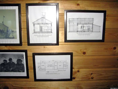
Ushakov's drawings for the cabin are also part of the small legacy.

The loneliest Museum keeper on the planet.


-----------------------

For arctic travelers with a tourist flare, the crashed Antonov is probably the main 'attraction' on the island.

On April 11, 2003 this Antonov An-12 was in a supply and rescue mission in Severnaya Zemlya.


Upon landing on Sredniy Island under zero visibility blizzard, the plane missed the runway for 650 meters; all nine crew members and five passengers were not injured, but the damaged Antonov was left to rust.


Leaving with a 2003 postcard from Ostrov Golomyanniy :