Friday, 7 October 2011

The arctic ermine - the dearest arctic creature!


Some time ago, I declared my admiration for the Arctic Tern as the most wonderful bird on the planet; now, I declare my sympathy for the Ermine, the most cute (though fearsome and deadly!) small mammal.


Ermines (Mustela erminea) live in the Arctic tundra of North America (Canadian high arctic), Greenland and Europe (Siberia). Their usual habitat: flat marshes, open spaces or rocky areas.


In the spring and summer they have brown to yellow-brown fur with paler or white fur on the belly and a black tip on the tail.


Ermine usually reach over 30 cm in length.

The head is triangular shaped with small round ears, small, bright eyes and long whiskers.


They grow white fur in the winter, but the tip of the tail remains black:

Ermine's black tail tip may draw any predator bird's attention and fool it into attacking the tail.

A small, white face pushes up through the snow, its black eyes gleaming brightly.


The ermine's flexible spine allows it to do the "marten run" in which the back is first arched, then extended.


Ermines are very territorial, and largely solitary animals.
Their life span is 4 to 7 years.

Elusive predators, ermines are cruel little killers for there preys mainly mice, lemmings, squirrels, small birds, but also rats and sometimes rabbits!

Ermine are largely nocturnal or crepuscular. Most of their preys are small rodents that live beneath the snow in winter. And in turn they are ferquent prey to wolves, foxes, cats and large birds.

A long time ago, during the Middle Ages, the fur of the white phase of the ermine was popular in clothing, and had a strong symbolic meaning of purity.
"Ermine" portrait of Elizabeth I by Nicholas Hilliard, 1585

Nowadays ermines are almost never used in clothing.

Ermines were also choosed to figure in some coats-of-arms, because of that purity symbolism.

Ermine in Chateau-Blois window

Ermines are neither threatened or endangered. The world population is some trillions !


Monday, 26 September 2011

Sites with history in the canadian Arctic:

Sachs Harbour, the Aulavik Park, and the wreck of the Investigator

Banks Island belongs to the Arctic Archipelago, on the Canadian Northwest Territories

The island has one settlement, Sachs Harbour, and a National Park, Aulavik

Sachs Harbor, pop. ~140

Latitude: 71° 58' N; Longitude: 125° 12' W


Sachs Harbour or Ikaahuk ("place where one crosses") is the most northerly community in the NWT of Canada. Sachs Harbour is the only permanent settlement on Banks Island, situated on its southwestern shore, and is the nearest community to Aulavik National Park. The settlement is also known as the "Muskox Capital of Canada".

It has a small airfield and terminal, a school, a nurse health center.

Sachs Harbour

Facing the Beaufort Sea

Dreadly cold winters

The Aulavik Park

Aulavik National Park is on Banks Island, the most westerly island in the Canadian Arctic Archipelago. The Beaufort Sea lies to the west. To the northeast, M'Clure Strait separates the island from Prince Patrick Island and Melville Island.

Banks Island is tundra territory, with extremely cold winters. The island is home to barren-ground caribou, polar bears, muskoxen - 68000 muskoxen live on the island, the majority of the world's population.

Paddling on Thomsen River observed by musk-oxen.

The heart of Aulavik National Park is the Thomsen River. It runs through the park, and is the northernmost navigable river (by canoe or kayak) in North America.

The park encompasses a variety of landscapes from fertile river valleys to polar deserts, buttes and badlands, rolling hills, and bold seacoasts.

Spring in Aulavik

Arctic cotton

Gyrfalcon bluff

Arctic fox

Tundra ermine in summer


The wreck of the HMS Investigator

In September 1851, Captain Robert McClure's ship, HMS Investigator, became ice trapped in Mercy Bay, Banks Island, during his search for the lost Sir John Franklin Expedition, ordered to complete a crossing of the Northwest Passage, which had already been charted from both the east and west but had never been entirely navigated.

The HMS Investigator, built at Scotts of Greenock and bought by the Admiralty in February 1848, has now been found by a team of Parks Canada scientists after 156 years since it was last seen.

HMS Investigator was strengthened with iron reinforcement for Arctic services; in 1848 she set sail, in search for the missing Sir John Franklin expedition in quest of the Northwest Passage: with two other lost ships, HMS Erebus and HMS Terror, it had made up the ill-fated 1845 British Arctic Expedition that failed the attempt to cross the passage through the Arctic.

HMS Erebus and HMS Terror trapped in the ice

Having only found some graves and human remains, and failed again the attempt to sail through the deep frozen Arctcic ocean, then on the return voyage, which was commanded by Robert McClure, HMS Investigator itself became trapped in the ice.


Three years later, on June 3rd 1853, her sixty-nine man crew were forced to abandon ship. She was finally abandoned in Mercy Bay, Banks Island. Most of the crew went on to survive for three winters, though in the most unimaginably desperate conditions. They were finally rescued in Melville Island.


The Investigator's remains were found on the shores of the island with the deck of the ship roughly eight metres below the surface of the water. The Canadian archaeologists found the ship "largely intact" sitting upright in approximately 25 feet of pristine arctic water.

(The HMS Erebus and HMS Terror wrecks are yet to be found)

Wednesday, 14 September 2011

Point Hope, overlooking the Chukchi Sea


In my wandering quest for Ultima Thule, this time I'm back in Alaska, in the western-most extension of the northwest Alaska coast, southwest of Barrow, called te North Slope.

This is no soft beauty - nature is harsh, civilization too far away, life is back to basics, no comfort, no modern luxury. Isolation is heavy on everyday living, but things got a lot better with, first, the building of the new well-equiped school and a good library, and second, internet access for all.

Point Hope, Alaska
Population ~750
Location 68º 21' N , 166º 47' W, 200 miles north of the Arctic Circle.


Point Hope (Tikiġaq) is located near the tip of Lisburne peninsula, a large gravel spit in a lowland area with several coastal lagoons facing the Chukchi Sea, south of the Arctic Sea and north of the Bering Strait.

The settlement got its name from a visiting british captain in honour of an englishman family "connected with the sea". But it had been for centuries inhabited by native Inupiat Inuit people.

Lisburne peninsula is in fact one of the oldest continuously occupied Inuit areas in Alaska.

Welcome

The climate is arctic. The Chukchi Sea is frozen most of the year, but ice-free from late June until mid-September.

Point Hope in the distance, seen from frozen sea

Point Hope residents are dependent upon marine subsistence.
Ice conditions allow easy boat launchings into open leads early in the spring whaling season.

Native whalers launching the umiak

This highly favorable site, with its abundant resources, has enabled them to retain strong cultural traditions, after more than a century of outside influences. The history of Point Hope was strongly influenced by whaling, trading and caribou herding. Walrus and occasional polar bears are also traditional resources.

Umiak with harpoons in place
The umiak is made of animal skin on a wood frame

Seal skin covered umiak

Caribou herd

Some local facilities:

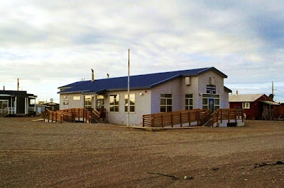
For shopping

Tikigaq School, the second largest in Alaska, serving more than 250 children

At the Youth Centre's library

The Post office

The igloo-shaped Community centre

Dressed for the cold

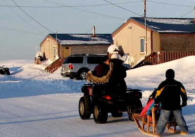
Typical house and sled

A wealthy native family: SUV car, 4 wheeler and sled.

At June's whaling festival: inuit drum playing and dancing
Whale bones are strong native symbols


Point Hope at sunset


Cape Thompson

Cape Thompson is a headland on the Chukchi Sea coast of Alaska.
It is located 26 miles to the southeast of Point Hope.


Towering spires and cliffs host giant rookeries

The cape facing ice floes in Chukchi Sea

Chukchi Sea at sunset: