Monday, 31 December 2012

Around Marguerite Bay, Antarctic peninsula:
three research stations

Marguerite Bay is a major bay on the west coast of the Antarctic Peninsula, along the Fallières Coast. The bay is bounded on the north by Adelaide Island and on the south by George VI Sound and Alexander Island.

In the background, the Antarctic Peninsula with the Ice Shelf on the Fallières Coast.

George VI sound, a 483 km long bay, usually frozen, between Alexandra Island and the Peninsula coast.
Located at 71°S, 68°W

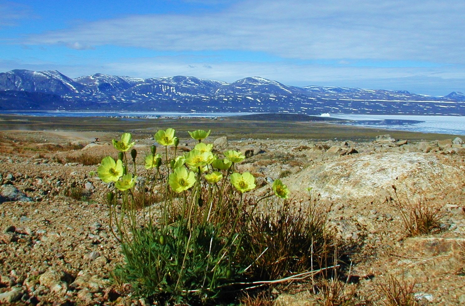
By this time of the year, Summer is reaching its best days in Antarctica.  Temperatures may rise from -10º to 5º at most, and even some forms of vegetal life show up on rocks, now free of ice.

Three research stations are located close to the shores of Marguerite Bay: San Martin, an argentinian base at the small Barry Island; Rothera and Fossil Bluff, two UK bases, at the large islands of Adelaide and Alexandra.


San Martin, Barry Island

Barry Island is a small island, one of the Debenham Islands.
Coordinates: 68°08′S, 67°07′W.


Barry Island was charted by the British Graham Land Expedition (BGLE) under John Riddoch Rymill, who used the island for a base in 1936 and 1937.


Argentina built the San Martín base in 1951, located on this island. Around twenty people live there all year round.


San Martín was for many years the southernmost station in the world, south of the Polar Circle. 


Maguerite Bay (or Margaret Bay) is a place of wonderful iced mountains scenery:

 At sunset

 
Through the 24-hour sunlight days of summer

--------------------------------
To the west:

Rothera research station, Adelaide island
At 67° 34’ S, 68 ° 08’ W

The island is 140 km long and heavily glaciated with mountains of up to 2565m height. The station is built on a promontory of rock.


BAS Rothera Station was established in 1975 to replace old Adelaide Island Station. It is a large facility open throughout the year, and in the summer the population will peak at just over 100 people.


In the winter months, April to mid October, a compliment of around 22 will be continuing the science work and looking after the station infrastructure.

The Bonner laboratory, a state-of-the-art facility for terrestrial and marine biology: three dry labs, one wet lab, aquarium, library, microscope room...

Bransfield House, where the main comunity services are located, is the hub of the base: dining room, bar, library and TV rooms, computer rooms, communication facilities, meteorological facilities, dried food storage and kitchen.

Rothera serves as the capital of  the British Antarctic Territory.

The docking quay has regular visists from the BAS ship RRS James Clark Ross

The base also has 2 Twin Otters that allow fast support to Fossil Bluff station.

Stonehouse bay, a large body of water.  
Adelaide Island's largest glacier, the Shambles Glacier, calves into this bay (far right).

------------------------------
To the south:

Fossil Bluff, Alexandra island, George VI sound

Latitude 71°20' S, Longitude 68°17' W

This small base was established on Alexander Island in 1961. It is about 225 miles south of Rothera,


With summer-only occupation since 1975, the bluff is a collection of buildings and facilities, at the centre of which lies the hut.

Fossil Bluff only houses four people.

 The main hutt, named Bluebell Cottage

The base is operated by Twin Otters from Rothera station (90 to 110 minutes flight)  during the Antarctic summer season.

Giza Peak, backing the station to the West.


Summer in Antarctica can also be colourful:

Antarctic Pearlwort, a rare flowering plant in the Antarctic region, extends to as far as 60º South along the western coast of Antarctic Peninsula.

An almost-sunset at Rothera, the night of a long Summer day.

------------------------
This was my New Year post. Happy 2013 for all visitors!

Sunday, 23 December 2012

Christmas wishes

Delightful rest, beloved pleasure of the heart

Bernarda Fink sings one of the most sublime Bach arias: Merry Christmas for all, and happy holidays!

Saturday, 15 December 2012

The long arctic night

In the high arctic latitudes, the sun is absent for two months. But sometimes, lucky days, the full moon shines:


Down here in lower latitudes we don't often value the precious sun light and warmth. Those are priceless but free gifts to be thankful for.

Photo: Carl Skou, Kullorsuaq, Greenland

Wednesday, 12 December 2012

'Le' Wildcat Café - heritage site in the Northwest Territories, Canada


The Wildcat Café is located in the heart of Yellowknife, on old town's Wiley Road.


Coordinates 62°27′N, 114°20′W

In 1992, the cabin was declared a heritage site as an important old building, one of the earliest permanent buildings in town.


Built in 1937-1938 by prominent pioneers Willie Wiley and Smokey Stout, the Wildcat is a reminder of pioneering days.


The Café is a vintage log cabin structure and represents the mining camp style of early Yellowknife.


The Wildcat was a gathering place for the founders of Yellowknife: prospectors, miners and pilots.

Prospectors wheeled and dealed, community members held meetings and banquets, while visitors came and went.


Great place to try caribou, bison, muskox, arctic char in addition to the usual cuisine. And a coffee.


In 2011, the city of Yellowknife decided to completely renovate the log building, which had settled far into the ground and was leaning dangerously in several directions at once.

Reconstruction and repair continued during the summer of 2012 and the opening has been delayed due to a number of unforeseen problems.


The Wildcat Cafe is currently scheduled to reopen in the summer of 2013. It is now one of Yellowknife's most popular attractions.

The residents only disagree om the article : Le Wildcat, or The Wildcat ? As for now, the The wins.


It is surely a warm comfort to have a nice coffee in the Wildcat.

Wednesday, 28 November 2012

yupiii, 150 000 at last !

Celebration day, as I reach a magic number of viewers, one hundred and fifty thousand!

This is the statistic of the 10 most visited posts on Ultima Thule:

8743


6527


6280


4099


2660


2561


04/09/2010, 3 comentários
2032


1549


1439


1430


(I still wonder why Oymyakon is the winner...)

Thank you all so much !

Friday, 2 November 2012

Winter in the Arctic, Summer in Antarctica

As the arctic prepares for some months of long dark night...


... in the extreme south arrives a short summer, not warm but as good as it gets.


This is the best time of the year in Antarctica, with luck you can even find some flowers !

Have a nice summer down there, people of the iced South!

Tuesday, 23 October 2012

Qikiqtarjuaq, Broughton Island, door to the Auyuittuq Park


Qikiqtarjuaq (meaning big island ) is located just north of the Arctic Circle and off the east coast of Baffin Island, in smaller Broughton Island (only 12 by 16 km).


A narrow strait of 3,5 Km separates the two islands, and at east Greenland is close by across Davis Strait.

The village is set in a glorious arctic scenery, in a large bay surrounded by mountains that in sunny days reflect on the quiet waters.


Population: ~520
Latitude 67° 33’ NLongitude 64° 01’ W


One of the more traditional communities in Nunavut, Qikiqtarjuaq is known for its traditional Inuit and modern clothing, including sealskin parkas and kamiit (skin boots).


Abundant wildlife and beautiful scenery attract visitors to Qikiqtarjuaq, often called ‘Qik’ for short.

In the 1800s, European whalers would crisscross the Davis Strait between Greenland and Baffin Island to trade goods with the local Inuit people.


Qikiqtarjuaq is also the ‘Iceberg and Diving Capital of Nunavut’. The community has several local certified divers available throughout the diving season.

A nine-room inn, the Tulugak Hotel


Sunset at Qikitarjuaq bay

More infos : here and here
 
Broughton Island


Some views :


Aerial view

The east coast,looking to Greenland across Davis strait

Cape Broughton also looking east

In spring landscape is decorated with artic flowering like these poppies.

AUYUITTUQ PARK

Qikiqtarjuaq is conveniently close to the northern boundary of the majestically mountainous Auyuittuq National Park in Baffin Island, a closer door to the park than the southern hamlet of  Pangnirtung.

Coordinates 66°32′N, 65°19′W

Auyuittuq National Park has amazing glaciers, waterfalls, sheer cliffs, semicircular valleys, flat-topped peaks like Mount Asgard or steep peaks like  Mount Thor:

Mount Asgard

Mount Thor, a famous steep cliff 1675 m high

Auyuittuq’ in Inuktitut language means ‘land that never melts.’ Established in 1976, this national park protects 19 089 square kilometres of pristine, glacier-scoured arctic terrain. The Inuit people have used this majestic land for thousands of years as a traditional travel corridor.


Auyuittuq Park deserves by itself a dedicated post here, I will publish it as soon as possible.