
Barrow is the largest city of the North Slope Borough in Alaska, and the northernmost city in the United States, 550 km north of the arctic circle.
 Barrow is located in a lowland tundra coastal area among lagoons, and has been flooded recently by the arctic ocean rising levels.
Coordinates: 71°17′ N, 156°45′ W
pop. ~ 4600
Barrow is roughly 2100 km south of the North Pole.

Welcome to Barrow (in inupiaq, Ukpeagvik = "place where owls are hunted")

The town center, with the sign post, the visitor center and the Airport Inn lodge.

Free coffee for tourists! :)

Better in summer...
Nearby, at 14 km to the northeast, Point Barrow is the nation's northernmost point.
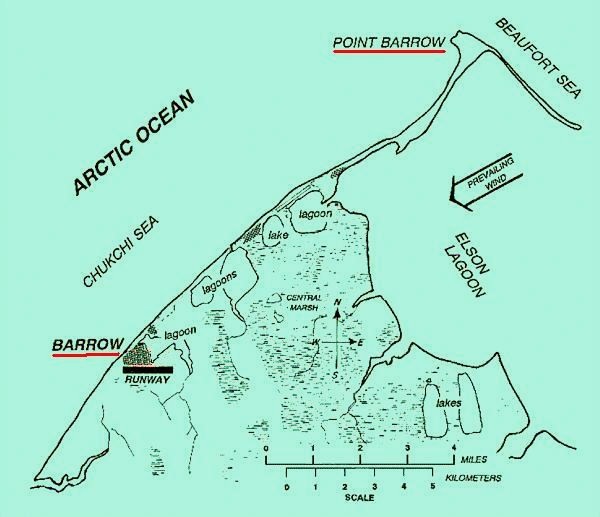
Point Barrow is also an important geographical landmark, marking the limit between two marginal seas of the Arctic, the Chukchi Sea on its western side and the Beaufort Sea on the eastern, both delimited to the North by the edge of the map.
The sea water around is normally ice-free for only two or three months a year.
Barrow’s local economy is based on oil but is supplemented by tourism, with visitors arriving during the summer season to enjoy the midnight sun.
Average daylight:

24h in summer months, zero in winter...

The King Eider Inn, in the town center, under twilight moon.

The fur shop and Iñupiat cleaning facility

The Town Hall in the arctic night

Iñupiat whalers launching the umiak at the Chukchi sea
Hunting and fishing are still important for subsistence. Many residents rely upon subsistence food sources: whale, seal, polar bear, walrus, waterfowl, caribou, ducks and fish are harvested from the coast or nearby rivers and lakes.


The houses have to be built on stilts to isolate from the frozen permafrost soil of the tundra. The heat from the house would melt it and the house would then sink.

Colourful houses bring some joy to the grey days
The historical town center

Oldest house in Barrow

The main presbyterian church, Utqiagviq
Barrow schools:

The elementary...

...and the secondary school.
The Post office

One of the best buildings in town


Old postage from the "top of the world".
The Iñupiat Heritage Center

A museum with many fascinating Iñupiat displays and artifacts.


Ivory bear and cubs

Ivory kayak
The Iñupiat Heritage Center celebrates Eskimo contributions to whaling.

Local inupiat drummers
Archaeological evidence dates human habitation (by Inupiat Eskimos) in the area from about 500 A.D.
The small town was named in 1826 by british explorer Frederick William Beechey, for Sir John Barrow, geographer of the British Admiralty.
In command the HMS Blossom, Beechey explored the Bering Strait in concert with Franklin and Parry expedition operating from the east. In July 1826, he named the three islands in the Bering Strait. Two were the Diomede Islands. Later in the summer of 1826, he passed the strait. Sailing north, the expedition then reached Point Barrow, hoping to meet somewhere around with Parry. But that meeting would fail for a 5 days (300 km) gap.
Shopping

Restaurants:
 Brower's Café
Occupies the most historic building in town, the 19th-century whaling station and store built by Charles Brower, who introduced a new whaling technique to the Iñupiat.


Big windows look out on the beach and a famous whalebone arch is just outside.
Northern Lights
Northern Lights

Their menu starts with the owner's own Chinese food, plus deli selections and burgers, and great pizza.
Pepe's North of the Border

The most famous place in town thanks to an appearance. Crowded sometimes.

Mexican food, steak, and seafood.
The King Eider Inn

Airport
Barrow is connected with Anchorage and Fairbanks by regular air service.


Midnight sun dims the arctic ocean, through the arched whalebones, Barrow's logo..

Alaska 55 for Anchorage

The Alaska Airlines terminal
----------------------------------------------------

Visitors to Point Barrow receive a certificate as they were at the "land's end".

Driftwood from an umiak at the beach as the sun sets


