Sunday, 7 May 2017

Old Crow, an Arctic native village in Northern Yukon, Canada


This time we travel to the Beaufort Sea coast of Yukon, west of the McKenzie Delta, and then southwards inland. This is a Gwitch'in ethnic region, a native population living around the Porcupine River lowlands and mostly settled at the village of Old Crow.


Their name means "people of the lakes". Other smaller communities can be found at Fort Yukon, Fort McPherson and the NWT region's capital, Inuvik.


At the banks of Porcupine River, south of the Ivvavik and Vuntut Parks, Old Crow benefits from a pristine natural taiga surrounding.

Flatland taiga covers Porcupine River basin at northern Yukon.

Old Crow ('Teechikin Gwich’in) is an inland community in Canada's Yukon Territory, in periglacial environment. The community is situated by the Porcupine River - tributary of the large Yukon River - in far north Yukon region. It's the only settlement there north of the Arctic Circle.


At over 67º North, Old Crow experiences a sub-arctic climate, which means long, cold winters, and a short but sunny summer.

The old mission cabin welcomes visitors, though amenities and accommodation are very limited.

Old Crow's main road, featuring the wide façade of the Community center.


Old Crow is the only Yukon community that cannot be reached by road.

Coordinates: 67° 34′ N, 139° 48′ W
       (~ 120 km north of the Arctic Circle)

Population: 250-300, Vuntut Gwitchin                                       First Nation


Harvesting caribou is essential to the livelihood and the traditions of the Gwich’in people. Their main sources of livelihood are trapping, hunting and fishing. The Porcupine Caribou provides meat and skin for boots, moccasins, mitts, traditional outfits, and even decorative housewares.

A local's log cabin typically decorated with caribou antlers.


The old Mission cabin, now b&b, from 1935.

Old Crow School


The Health Center and Nursing station.

The Old Crow Health Centre was built in 1960 and later upgraded in 1985. This large building houses a clinic, offices for staff, a visitor's suite, storage space. It is staffed year round by two Nurses.

Royal Canadian Mounted Police (RCMP) detachment.

The anglican church of St. Luke.


St. Luke’s Anglican Church was built in 1959 to replace the community’s original church. This log building echoes with memories from the past.

Renewable power station

A project of Solar Energy power has been implemented since 2014 by the local Vuntut government to decrease costs and reduce gas emissions.


Old Crow's thermal amplitude can be huge - a record of -61ºC in January to +36ºC in July. In winter, 12-14 days of full polar night happen in December, but over 3 months of midnight sun happen from May to August - that's when the Solar Energy system will be fully profitable.
What a climate show !

Old Crow's Community Center

The Community Center is where most things happen at Old Crow: traditional potlatches, dances, concerts, lectures, handcrafting, courses...

Inside the Community hall, photographs of community Elders, past and present, are hanging on the walls.

Gwich’in men are well known for their crafting of snowshoes, birchbark canoes, and the two-way sled. The women are renowned for their intricate and ornate beadwork. They also continue to make traditional caribou-skin clothing and porcupine quillwork embroidery.

Beading on slippers.


Hand made caribou skin boots.

Gwich'in embroidery, dog blanket.

Baby bag, porcupine embroidery


The only way to access the community is through the Old Crow airport.

"Air North" flights link Old Crow to Dawson City and Inuvik.


Ivvavik Park and the Porcupine River


Initially named "Northern Yukon National Park", Ivvavik Park was renamed in 1992. The park protects a portion of the calving grounds of the Porcupine Caribou herd and represents the Northern Yukon and Mackenzie Delta natural regions.

The Porcupine River (Ch’ôonjik in Gwich’in) is a 916-kilometre tributary of the Yukon River in Canada. It flows north through the community of Old Crow, crossing a taiga land covered by small and larger lakes.

Old Crow and the landing strip are visible up left, in one of the meanders of the Porcupine.

A landscape where plants and animals managed to survive in a land where Arctic and sub-Arctic meet.

Caribou crossing herd, Porcupine river.

Caribou hunter, Porcupine river.

The boreal taiga forest in the Parks and banks of the Porcupine is mostly above the arctic circle, as the tree line here is displaced to a higher latitude; spruces, birch, alder, larch and willow manage to survive in the cold. But the northern and coastal strip of Ivvavik Park is treeless arctic tundra.


Sunday, 9 April 2017

Tvøroyri, small port town in the southernmost Faroë Island


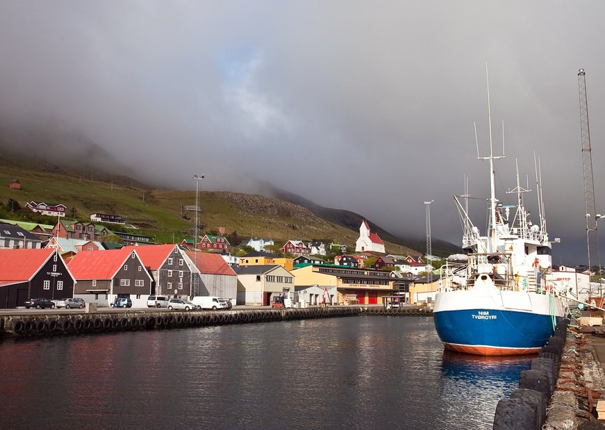
Tvøroyri is the main village on the island of Suðuroy, the southernmost of the Faroë Islands, on the North Atlantic.

The small fishing town is located at the bottom of the fiord Trongisvágsfjørður.


Tvøroyri sits like a ribbon-shaped urban agglomeration along the north shore.

The historic waterfront of Tvøroyri, at left, faces the main harbour across the fiord.

The setting is typical of a nordic fiord.

Tvøroyri, Sudoroy, Faroë Islands

Coordinates: 61° 33′ N, 6° 48′ W
                      (sub-arctic)
Population: ~ 1750

The old warfs have been restored, as they are the village's first impression.

This is now a leisure area, quite lively in summer.

The M/S Thorshavn (built in oak and beech, Denmark, 1940) now serving tourist cruises.


The Sail Loft (Seglloftið)

This was the old sail making house.


As part of of the old merchant port, the building is now a cultural venue, as are the black painted old warfs.

The most famous window in Tvøroyri...

... and its view: the old Krambúðin.

Krambúðin

Krambúð means shop in Faroese.


The first house to be built in Tvøroyri was the old shop, which the Royal Trading Monopoly built in 1836. Since 1856 this building has been known as Krambuðin (grocery shop).


The interior has only undergone minor changes and still has the appearance of a grocery shop from the old days with shelves and drawers and the original National cash register from 1872.


Tvøroyri Museum Doktarahúsið

In the vicinity of the quay, the local maritime museum is installed in the old doctor's surgery, kept authentic with a grass roof.

Doktarahúsið, the Doctor's House.

This museum tells the local history of Tvøroyri and the fiord area around. It is a historical and maritime museum.


The building is one of the first built in Tvøroyri, from 1852.


Cast iron work


Traditional faroese dress and jewelry.

Gallari Oyggin


The Gallari Oyggin ('Island Gallery') is situated on the main street in Tvøroyri. There are sculptures in the garden and on the parking spot, opposite the gallery.


The owner is Palle Julsgart, who is an artist himself. The Oyggin Gallery has shifting exhibitions with guest exhibitors from the Faroe Islands and from other countries. The café in the gallery serves light dishes and drinks.


Site:
http://visitfaroeislands.com/place/gallery-oyggin/#sthash.iSiJX7QY.dpuf

The shop

Tangabúðin, Sjógøta (Opposite of the Art Gallery Oyggin).

Owned also by Palle Julsgart, this cosy little shop opposite of the Art Gallery sells gifts, books and framed works from local artists. On the square next to the shop there are several sculptures.


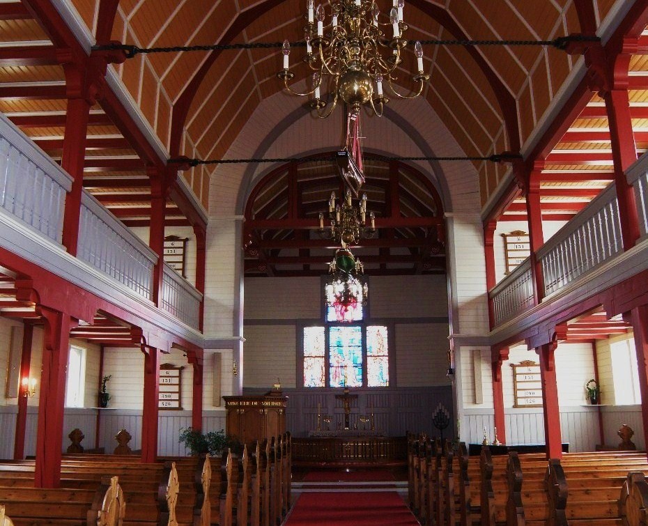
Tvøroyri church


On the east side of the village, high on a hillside over of the town, and visible from far away.


The prebuilt wooden church was shipped to Tvøroyri and assembled in 1907.


The fiord and the water festival Jóansøka

Tvøroyri harbour is protected as heritage but also for its strategic value. Twelve fishing vessels have their home port here. As measured by the fleet, this is the fifth most important port of the North Atlantic archipelago.


The island's traditional boat, called 'Smyril'.


Each year Tvøroyri and Vágur take turns with the celebration of a midsummer festival, called Jóansøka, the St John's feast.


Several proofs of rowing take place in traditional smyril boats.

The modern ferry, baptised Smyril V, watchimg protectively a Smyrill race.

This festival takes place every year on the weekend that falls closest to June 24 (St. John's day).

Jóansøka in uptown Tvøroyri.


The daily ferry from Tórshavn docks at Drelnes, opposite on the south shore of the fjord. The crossing from Tórshavn takes about a half hour with the new ferry Smyril V. The ferry serves not only passenger transport, but also trade with the outside world.

The new ferry sailing past Tvøroyri.

The winter snow brings a different look to the town and the fiord:

The church, above the town's main street.

Trongisvagur river mouth, into the fiord.


The Park of Trongisvágur


A popular excursion destination is the forest Viðarlundin í Trongisvági , one of the largest of the Faroë Islands, which are mostly treeless. It consists mainly of spruce, pine and ash and is located about 1 km west of the town.


The Faroese word Viðarlundin means little forest or little plantation.


The Faroë Islands, with their moist cool climate and salty air, are not suitable for the prosperity of trees; the soil crumb is also relatively thin and offers little support.

The road around Suðuroy offers some Faroë typical panoramics - a treeless but green covered land above large sea views.

One of the finest views is the Lilla Dímun island, close to the east coast of Suðuroy.

The west coast is quite more wild and rugged.

Under winter snow, Suðuroy has a quite different character.